
This document authored by Prof Dr MRD Kundangar in the early 1990s for the Hydrobiology Laboratory of the SP College, which he was heading, is one of the first detailed scientific monographs of the Dal Lake. It offers a detailed narrative of its history, scientific, social and economic worth for the Srinagar city and the problems it was facing. This was part of the many other documents that eventually were utilised in launching a full-fledged conservation project through LCMA (erstwhile LAWDA)
The Dal Lake has been the centre of Kashmir civilization and is among the most beautiful national heritages. It has played a major role in the economy of the state of Jammu and Kashmir through its attraction of tourists as well as its utilisation as a source of food and water. Traditionally the vegetable markets of Srinagar have been supplied from the famous floating gardens and irrigated land within the lake area.
During the past few years grave concern has been voiced by people from different walks of life over the deteriorating conditions of Dal Lake. There is no denying the fact that Dal Lake has fallen victim to human greed, as a result of which the entire ecosystem is rapidly changing. The water quality has deteriorated considerably during the last three decades. A large area of the lake has been reclaimed and converted into floating gardens. A large number of residential buildings restaurants and hotels have come up along the lakefront.
Over the years the lake has become shallow due to siltation and accumulation of plant debris. Many undesirable changes in the structure of biological communities have resulted and some important species have either declined or completely disappeared. In this monograph, an attempt has been made to record the ecological history of the lake and its eutrophic gradient as a result of varied anthropogenic perturbations.
History
Dal Lake (Lat 34_-6’N, 74_-45’E; Alt 1583m) is a post-glacial lake with a shallow depth bounded on the south-west by the capital city Srinagar and encompassed on the other sides by terraced gentle slopes at the base of precipitous mountains. It is a typical urban lake mainly used for tourist recreation. Fishery and harvesting of economically important water plants are of secondary importance.
During winter months the Dal waters are also used for drinking water purposes; as such six pumping stations each of five cusecs capacity have been installed on Dal-Bund near Nishat to meet the requirements of the consumers. The lake comprises five basins – Hazratbal, Bod-Dai, Gagribal, Nagin and Brari-Nambal, besides myriad inter-connecting channels.
The inflow channel known as Telbal Nallah enters the lake from the north and brings water from the high-altitude Marsar Lake. During its downward journey, the inflow stream collects large quantities of slit from the denuded catchment and deposits it in the northern basin of the lake. Several ephemeral water channels enter the lake from the human settlements and discharge large quantities of waste.
Within the lake basin itself, there are several springs which act as permanent water sources for the lake. Towards the south-west side an outflow channel discharges lake water into a tributary of Jehlum River. Parallel to this exit lies a stone-lined canal which connects the lake with a tributary and is used for the movement of boats in and out of the lake.
Flow of water in the channel is regulated by two big doors which are ordinarily open when the level of the lake is higher than that of the river. The doors are kept closed during floods to prevent the river water from going into the lake and the inundation of the floating gardens and human settlements. A small canal connects Dal Lake with Anchar Lake and acts as an additional outflow channel.
In History Books
There is no direct mention of the lake in Rajtarangni, the ancient history of Kashmir written by Kalahana in the twelfth century (Stein, 1961). However, the mention of two islands of the Dal Lake can be traced to this chronicle. Srivara’s treatise mentions that King Zainul-Abidin (1420-1470 AD) used the lake for recreation and beautified its surroundings.
The importance of the lake as a tourist resort is more than five centuries old. The famous Mughal gardens around the lake were laid during the 16th-17th century and their number was about five hundred but only a few of these have survived. In the 18th and 19th centuries, Srinagar city started growing towards the lake resulting in far-reaching changes in its surroundings. Bunds were laid that divided the lake into three sectors viz Bod-Dai, Lokut Dal and Soderkhun. This was the beginning of the changes in the flow pattern of the lake water which continues till today.
Hassan (1833) in his celebrated History of Kashmir popularly known as Tarikh-i-Hassan gives a detailed account of the origin and evolution of Dal Lake based on ancient historian Pandit Ratnakar (Ratnakarpuran) written 300 years earlier than Kalhan’s Rajtarangni. According to Hassan in olden times the site of the present Dal Lake was a plain desert which was known as Vitalini Marg. King Pravarsen closed the river Behat (now the river Jhelum) from the Nowpora side and brought the river into the city by way of the foot of Kohimaran (also known as Hari Parbat hillock). After a great deal of time, the river Jehlum rose in spate and as a result of the deluge, during the reign of King Durlab Vardhan (625-661 AD), the above-mentioned desert became a lake.
Sultan Sikander (1389-1413 AD) constructed a very strong bund upon it from Nayidyar to Nishat Bagh along with six bridges viz Choudhary Bridge, Dood Phokhri Bridge, Tulkhan Bridge, Gani Bridge, Oont Bridge and Nishat Bridge. Another Bund from Khawjayarbal to Aishabad (presently Ashai-Bagh) on Sodrakhun Lake (now the Nigeen basin) was constructed by Saif Khan (Governor of Kashmir who ruled the valley twice in 1647 AD to 1667 AD and 1668 AD to 1771 AD during the reign of Aurangzeb Alamgir).
Consequently, the Dal Lake was divided into three parts viz Bod Dal (in front of Hazratbal), Lokut Dal (expanse from Shankryacharia to Nishat Bagh) and Soderkhun (situated in front of Hariparbat). Among these three parts, the notable historian reports the heavily populated islands of Nundpora village, some of which have levelled with the ground and some others spread over the waters and are dragged off to the desired places. On these islands were grown watermelons and other varieties of vegetables that sufficed the people of the city.
The rhizomes of the Lotus plant, its seeds and sweet nuts were also among its production. Near the banks grew Phragmites and Typha, which were useful for mat weaving. Hassan describes that the water of the lake was as sweet and delicious and one could see the fish down below the clean waters.
The Sona Lank Island (presently 3-Chinari) in the Bod-Dai in front of Hazratbal was constructed by Sultan Zainul Abidin with a three-storey royal palace. The said palace according to the author fell by an earthquake. Afterwards, the Moghul Emperors built over it a sight-seeing tower. Ameer Khan (Governor of Kashmir from 1771 to 1774 AD) renovated it and drew the lake water to the Chinar tree and into the garden of the building through a Persian water wheel and also raised exhilarating fountains, the sight of which he used to enjoy very often.
In the Lokut Dal, a Ropa Lank island (presently known as Char-Chinari) was built by Sultan Hassan Shah (1475-1478 AD) but its building was destroyed in the Sikh period (1819-1843 AD). Hassan also states that the waters of the Dal Lake would flow into river Jehlum near Habakadal. King Zainul Abidin (1420-1470 AD) closed it at that place and dug out the Mar Canal inside the city allowing the flow of the lake water through this canal towards the cultivation of Pargana Achhin.
During the present century, Dal Lake underwent far-reaching changes close to its banks and also in the catchment. Two additional islands were built which further obstructed water movements. A road was laid along the south-west part to improve communication which separated a large part of the lake creating a marshy area along the fringes of Shankryacharya and Zabarwan mountains. This marshy land had since been reclaimed and developed into huge residential and commercial complexes. The other roads viz Northern Foreshore Road and Western Foreshore Road were recently constructed attracting urbanisation in terms of purchases of land and water surface on either side of the road.
Origin, Geology
Geological evidence shows that Kashmir was once a glacial lake which occupied the whole area of the valley. The lake found its outlet in the South-West of Srinagar a few million years back. Of this long burial among the rocks, there is ample evidence in the layers of sediments, mud and shells that have by now hardened into stone and solid rock, folded, contorted and faulted in many places along with the remains of plant and animal life that lived amidst them during different geological times.
There are two diametrically opposite views regarding the origin of Kashmir valley lakes. One of the views put forth by Danielle (1922) considered the present lakes viz Dal, Anchar, Wular and Mansbal have resulted from the progressive shrinkage of the ancient glacial lake. Enex (1978) supported this view and believed Dal Lake to be a remnant of the Pleistocene Lake.
There is another group which opposes this theory. According to de Terra and Paterson (1939), the recent Kashmir lakes are not considered relics of the Karewa Lake as their salt content, does not furnish any information – clay sedimentation was many times interrupted by fan deposition and all the lake beds are folded and exact correlation between laminated or various deposits is as yet not possible, also sedimentation was influenced by subsidence of the basin floor.
The Dal Lake, like other valley lakes, lies in the flood plain of the Jehlum River, whose broad meanders have cut swampy lowlands out of Karewa terraces. The position of the lakes shows that they are derived from enlarged oxbows and abandoned flood channels rather than from the progressive shrinkage of the ancient lake. The asymmetric position of the Jehlum River in the valley alone is sufficient proof of the shifting of its course promoted by the strong uplift of the southwestern flank. This is further supported by recent studies undertaken by remote sensing which also accounts for the asymmetric position of the lake. Wadia (1947) supported the view that the Kashmir valley lakes are formed from inundated parts of the Jehlum River.
Catchment
The total area of the Dal catchment is 346 sq km which is about twenty times more than the lake area.
The catchment consists of mountain ranges on its north, north-east side and on the other side it is enclosed by flat arable land. The main geological formations are Panjal trap, agglomerate slate Triassic limestone and clayey material. In some parts of the catchment freshly deposited alluvium is also present. The adjoining mountains have little vegetation. Denudation of forests is the outcome of human activity of the past.
Mukerjee (1921) reported that Arrah valley from Harwan upwards was rich in coniferous forest with a mixture of Cedrous deodara in higher reaches. These mountains therefore were not always bereft of vegetation as is seen now. Natural causes might be responsible for reducing the vegetal cover of the catchment. Around the lake shore, the lower land slopes of the catchment have been utilised for paddy cultivation, orchards and gardens.
The North catchment comprises mainly the outer suburbs of Srinagar city and is extensively used for paddy cultivation. The topography is very flat and drainage is via slow flowing canals and open drains which in parts are badly contaminated with sewage and rubbish. The Srinagar city catchment is fully urbanised and, in most parts, it drains via Nowpora, Jogilankar, Lal Bazar, Brari Nambal etc into the Dal lake.
Human Settlement
Human settlements within and on the periphery of Dal Lake are one of the main contributing factors to the environmental deterioration of the lake. Due to the population explosion and the rapid rate of urbanization, the pressure on the lake and its surroundings has increased alarmingly. Enex (1978) reported that a population of about 7500 people live within the houseboat area and an equal number outside this area on islands, boats etc. The total population living within the other catchments of Dal Lake has been estimated to be 178,000.
During 1971-1977 the population increased by 25040 people within the catchment area. There has been a substantial population growth of the people living in the Dal Lake area since 1977. According to recent estimates by the UEE Department, at least 3350 encroachments were recorded in Dal Lake during 1991-1993.
Encroachments are still on despite increased vigil and restrictive legislations and ordinances. Official estimates regarding the houseboat number are about three hundred although the actual number is much more. The sewage and sullage waste of these houseboats is directly discharged into the lake body. Solid wastes such as vegetable scraps, polythene bags, papers etc are dumped into the lake. Several latrines used by the residents have also been constructed over water.
Morphometry
One of the earliest records of Dal Lake morphology is that of Drew (1875), according to whom the lake measured five miles from north to south and two miles from east to west.
Hassan (1883) described that the Dal Lake measured approximately three miles long from Gagribal to Telbal and nearly two miles wide from Khawjayarbal to Nishat Bagh and it may again approximately be ten miles in circumference.
Lawrence (1895) estimated the length of the lake to be four miles and its width two and a half miles. The author reported that the lake was becoming shallower.
Stein (1899) confirmed the dimensions as reported earlier by Lawrence and gave the maximum depth of the lake to be 30 feet.
According to Mukerjee (1931), the deepest part of the Dal Lake is 20 feet.
According to Enex (1978), the total area of Dal Lake was 21 sq km out of which the open water area of five basins was 12.1 sq km.
Vass and Zutshi (1979) reported that the total open water area of the lake was 11.75 sq km and estimated the total volume of the four basins of the lake as 9.83 x 10⁶ cubic meters. Nigeen basin was found to be the deepest part (max depth 6 meters).
According to Kango and Fotidar (1982), the area of the Dal Lake shrunk from 23.4 sq km to 13.82 sq km during 118 years.
Zutshi and Rashiduddin (1983) based on maps and surveys of the lake by Thomas George Montgomerie (1856-60) and comparing the same with the latest dimensions reported that the open water of Dal Lake is 10.56 sq km. There has been a further reduction in the lake area to date and the shrinkage has been attributed to heavy siltation through the inflow channels and large-scale urbanisation.
Hydrology
The hydrology of Dal Lake is complicated by the extreme diversity of its catchment which ranges from Srinagar city with high population density to paddy fields and high mountain ranges. Furthermore, a large proportion of the flow from the Telbal Nallah is diverted for irrigation of paddy fields and gardens through a complex network of canals. Based on a gauging of the major streams over the past few years, Enex (1978) has computed an annual water balance for the lake. The average inflow has been estimated to be 291.9 million cubic meters of which 80 per cent is contributed by the Telbal Nallah and 20 per cent by other sources.
According to Vass and Zutshi (1979), the water level of the lake fluctuates appreciably as a result of varied amounts of precipitation received in the form of rain and snow and the changes in the quantity of water that flows into the lake from the feeding channels. The total outflow through Dalgate and Nallah Amir Khan was reported to be 213 x 106 and 27 x 106 cubic meters, respectively.
Heat Budgets
Vass and Zutshi (1979) while calculating the heat budgets in various basins of Dal Lake reported the maximum heat storage for all the basins during July, the values being 2137g Cal cm2 for the Hazratbal, 1556g Cal cm2 for the Nigeen and 2083g Cal C2 for Nehru Park basin. The minimum heat stored in January was estimated at 249g Cal, 384g Cal and 428 Cal for the Nigeen, the Hazratbal and the Nehru Park basin, respectively.
The heat budget for the Nigeen basin remained constant for June, July and August and thereafter the basin lost the stored heat. The loss was as low as 0.9g Cal day1 in July-August which rose to 6.65 g cal, cal day1 from January to March as against 10.3g Cal day1 during April and May, the maximum heat loss occurred from September.
The overall heat budgets for the various Dal Lake basins are low. The low heat budgets of small shallow lakes indicate inefficient heating according to Hutchinson (1957). In shallow lakes, however, the heat taken up by the sediments was estimated at 1400g Cal while the annual heat budget worked out to be 2240g Cal (Naumann, 1953). This according to the authors could be the reason for the low heat budget of Dal Lake too.
The morphometry and other physical features indicate that the lake has reached a certain degree of eutrophication.
Sediment and Silitation
Godwin-Austin (1880) reported considerable difficulty in arriving at any satisfactory conclusion as to the nature of the basins of the Dal Lake because of its being now deeply covered by alluvium. The sediment is grey in colour and shallow water type as the lake is now in a stage of filling up through plant growth and siltation. Sediment is mainly organic and is composed of large quantities of lacustrine material and marl. The soil particles in the Dal are fine and light brown as compared to the area near the feeding channel where the substratum is predominately silty. The dominant component is fine detritus containing slime of algae and especially diatoms.
According to de Terra and Paterson (1939), the rate of sedimentation is difficult to determine on account of variability of supply. It was assumed to be the highest in Hazratbal in comparison to other basins as the former receives an inflow channel loaded with stormwater and silt. However, this supply was checked and counterbalanced in the past by erosion through lake currents for otherwise the lake would have been silted up more rapidly. The present-day sedimentation is different from what it must have been during the past. Table 2 presents data on the distribution of detritus and mineral grain in three basins of the lake (after de Terra and Paterson).
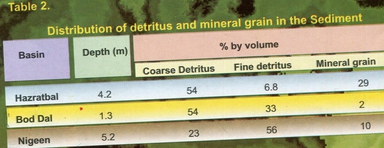
Given high silt transportation, the Hazratbal basin depicted the highest percentage of mineral grain in comparison to the other two basins. However, no detailed data is available on the seasonal silt load. Using average data of the silt input from the catchment Enex (1978) estimated that in 1979 the total volume of settled silt in Dal Lake by the inflow channel was about 36 x 106 cubic meters. This represents an area of about 3.6 hectares with a depth of one metre.
The impact of silt is visible in the north and northeast parts of the lake where appreciable reduction in water depth and the shrinkage of the area has taken place. The peak water discharge from the inflow channel during floods exceeds 2000 cusecs.
Zutshi (1968) recorded an increase in calcium, magnesium and potassium in the lake sediment on passing from the mouth of the inflow channel towards the centre of the Hazratbal basin. The author observed that in the vicinity of Telbal nallah the vegetation was sparse and towards the centre it became luxuriant.
Similar observations were recorded by Kundangar et al (1994-95). It is therefore presumed that the differential growth of macrophytes is mainly controlled by the mineral grain deposition and the slope orientation of the basin.
According to Zutshi and Vass (1971), lake sediments contain 0.16 per cent of Phosphorus and 0.33 per cent of Nitrogen. These nutrients were reported from the upper 20 cm layer. The estimated quantities of P and N in the sediment come to about 3.7×10² and 7.2×10² tonnes respectively which represents a substantial reservoir of nutrient pool potentially available for plant growth. This may be one of the reasons for the rich weed growth in Dal Lake.
Recently Kango et al (1986) reported a C:H ratio of 10:18 in the sediments with C=48.80 per cent, H=4.89 per cent and N=4.8 per cent.
Water Quality Changes
In a series of papers, Zutshi and Vass (1978, 1982), Vass and Zutshi (1978, 1983), Trisal and Kaul (1983) Kundangar and Zutshi (1986), Zutshi (1987), Kachroo and Suri (1987), Trisal (1987) Kundangar et al (1994-1995) provided extensive data on different aspects of Dal lake ecology. It was established beyond any doubt that the lake was undergoing far-reaching changes in its environment due to the discharge of large quantities of waste from human settlements, agricultural lands and houseboats. The ecological stress of the system is reflected by excessive growth of water weeds, deterioration of water quality, high incidence of faecal conforms and increased levels of biological productivity.
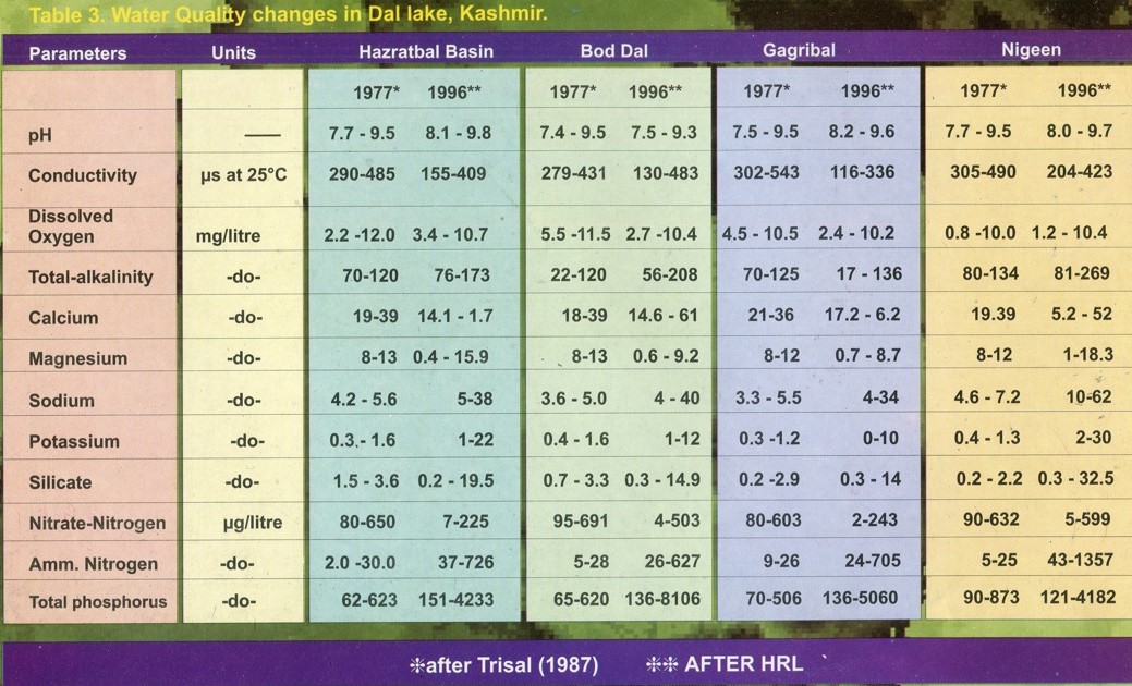
Table (3) gives a comparison of some important chemical parameters for the last eighteen years. It can be seen from the table that there is an increase in electric conductivity, alkalinity, calcium, phosphorus and nitrogen. The most significant changes have been registered in Ammonia, nitrate and Total phosphorus.
According to Enex (1978), a net flow of 5.5 tonnes of phosphorus and 88.9 tonnes of nitrogen is drained every year from the surrounding human settlements, hotels and arable land into Dal Lake. These figures are quite high for any type of shallow and relatively small body of water with a moderate water retention period.
Based on the energy flow chart presented by Vass and Zutshi (1983) for the Dal Lake ecosystem an overall photosynthetic efficiency is about 1 per cent. The major contribution is macrophyte vegetation. Plankton was observed to have low conversion efficiency which according to the author ranged from 1.12 per cent to 0.17 per cent. The authors reported that most of the energy fixed by aquatic weeds is lost to the system and to make use of this component it would be useful to induce grass carp. This author along with other associates is presently monitoring the effectiveness of the Urban Environmental Engineering Department Project in conserving the ecosystem. The results obtained so far do not indicate any definite improvement either in water quality or in the control of the proliferation of weeds.
Biodiversity
Phytoplankton: Qualitative and quantitative studies on phytoplankton growing in Dal Lake have been reported in detail by Kant and Kachroo (1973-1974, 1977), Trisal (1977), Vass (1980), Mir and Kachroo (1982), Zutshi and Vass (1982), Yousuf and Parveen (1986). Recently Kundangar et al (1994a-95b), while studying the distribution, species composition and population density of phytoplankton in the Nehru Park basin of Dal Lake recorded 139 taxa of which 62 belonged to diatoms, 55 to green algae, 14 to blue green algae, 4 to Euglenophyceae and 4 to Dinophyceae. The predominant species include Amphora spp. A ovalis, Cocconeis placentula, cymbelia spp. Gomphonema olivaceum, Navicula spp. Nitzchia acicularis and Synedra ulna (Diatoms); Cosmarium spp. (Green Silgae); Anacystis sp. Merismospedia sp. (Blue green algae) Euglena rubra (Euglenophyceae).
In the Hazratbal basin, a total number of 110 species of phytoplankton were recorded and the predominant ones among the Diatoms being Amphora ovalis, A proteus, Cocconeis placentual, Cymbelia ventricosa, Fragilaria capucina, Navicula sp. Nitzschia sp. N.acicularis, Synedra ulna. Among the green algae Ankistrodesmus spiralis, Microspora sp., Scenedesmus bijugatus, S.quadricauda. The blue-green algae were dominated by Anacystis sp. Microcystis aeruginosa, Nostoc sp. and Oscillatoria sp. Euglena rubra and phacus were dominant among Euglenophyceae.
However, the sequence of dominance of various algal classes in terms of numerical abundance in various studied basins of Dal Lake was:
Bacillariophyceae > Chlorophyceae > Cyanophyceae > Euglenophyceae > Dinophyceae.
The seasonal values of phytoplankton biomass range between 0.34 and 3.505g/ m3, the Chief contributors of biomass being Chlorophyceae and Bacillariophyceae. The overall biomass values reveal Dal Lake to be moderate to low in planktonic growth (Trisal, 1987).
Periphyton, Epiphytic Rotifers
Sarwar (1985) reported significant quantities of periphyton, both on natural and artificial substrates in Dal Lake indicating the high fertility of the system. The mean biomass accumulation was also high in Dal Lake as compared to other valley lakes. The author registered a total of 178 periphytic taxa of which the dominant forms were Acnanthes minutissima, Cocconeis placentuala, Cymbelia ventricosa, Fragilaria crotenensis, Navicula radiosa, Crucigenia tetrapedia and Microcystis aeruginosa. Among the natural substrates Myriophyllum spicatum and Nymphoides peltata supported rich and varied type of periphytic growth in comparison to other substrates.
Zooplankton
Recent studies by Kundangar et al (1994, 1995) registered 62 zooplankton species from the Nehru Park basin and seventy-five from the Nigeen basin of Dal Lake. According to the authors the sequence of the dominance of various zooplankton groups depicted the following pattern:
Surface water = Rotifera > Cladocera > Copepoda
Bottom water = Cladoera > Rotifera > Copepoda
The predominant zooplankton species recorded at the investigated sites of Dal lake include Keraatella cochlearis, Brachionus plicatila, Monostyla bulla, Lepadella ovalis, Polyarthra vulgaris, Rotaria sp. (Rotifera), Chydorus sphaericus, Bosminia longirostris, Alona costata (Cladocera) Paracyclops affinis and Nauplii (Copepoda). The dominance of rotifera has been attributed to selective predation by planktivorous fish and the overall low population of zooplankton is presumably due to the sustenance of a relatively lower concentration of phytoplankton. According to Kaul (1982), the zooplankton depicted two biomass peaks which are related to phytoplankton biomass peaks, thereby showing a typical succession of phytoplankton-zooplankton communities.
Bacteria
A sanitary survey of the microbiological quality of Dal Lake water was conducted by the National Environmental and Engineering Research Institute (1972), followed by the Enex report (1978). The most probable number of coliform organisms showed a range from 640-2400 (MPN/100ml) and that of faecal streptococci from zero to 2400 (MPN/100ml).
This indicates the possible contamination of lake water due to the entry of sewage or faecal matter. These coliform bacteria are native to the gut of warm-blooded animals and leave the gut via faecal discharges. As a group, these microorganisms are considered indicators of the possible presence of bacterial pathogens (Salmonella, shigella, typhoid, cholera) and enteric viruses. Very recently Hydrobiology Lab in association with Sheep Husbandry Research Lab conducted a series of tests and reported the average of Coliforms E Coli to be around 180+(MPN/100ml) at various polluted sites of Dal Lake.
Aquatic Weeds
Aquatic weeds in Dal Lake play a key role in the ecological functioning of the lake as they lock up large quantities of nutrients in their roots and rhizomes or even in sediment which supports a large number of weeds. Although many constituent factors of the environmental complex govern the distribution and production of aquatic vegetation, the changing water chemistry due to effluent enrichment, physical contours, and silt loading, besides the waste waters from the catchment areas appear conducive to the build-up of organic sediment throughout the lake area, an important factor for the recurring dense growth of aquatic plants
According to Mukerjee (1901, 1925, 1926), aquatic weeds were dominated by Potamogeton, Hydrilla and Myriophyllum besides the Chara species forming dense carpets close to the lake bed. The shallow water association was dominated by Typha, Sparganium and Carex species. In 1934, Mukerjee recorded three genera and eleven species of Charophytes from water regions of the lake with less than 1 per cent of light penetration.
Hutchinson (1934) reported rich vegetation from shallow parts of the lake which include Potamogeton lucens, Limnanthemum nymphoides and Polygonum amphibium. In deeper parts, P pectinatus, Ceratnphylum demersum and Charophytes were quite common. The entire floor according to him was found to be carpeted with vegetation. Later studies by Zutshi (1968, 1975), Zutshi and Vass (1971, 1973) and Koul et al (1972) have shown that the vegetation of Dal Lake had undergone significant changes during the decade.
According to Trisal (1977) rooted floated leaf macrophytes viz Nymphaae alba, Nymphoides peltata and Nelumbium nucifera occupied 29.2 per cent of the total area of the lake. Free-floating macrophytes like Salvinia natans and lemna species were distributed throughout the lake area in sheltered pockets. Submerged aquatic weeds due to their high aggressive capacity cover the maximum area (57.6 per cent) in all the basins of the lake. According to Zutshi and Vass (1932), about 6.8 sq km (55-60 per cent) of the total area of Dal Lake is under submerged vegetation. The contribution of organic matter production by submerged species is 4.62 tonnes ha1 yr1. Aquatic weeds are the main contributors to photosynthetic carbon fixation in Dal Lake.
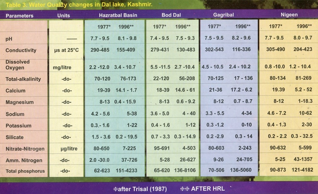
Table 5 presents the data on the macrophytic biomass of various life form classes, and it is thought these weeds occupy lesser areas than the submerged and rooted-floating-leaf type. High primary productivity of Typha anqustata and Phragmites communis has been reported by Trisal (1977) and Kaul et al (1978). Taking an overall view of submerged production in several lakes from existing data, Dal Lake sustains highly productive macrophytic communities, particularly in comparison to some Russian and Polish lakes.
Analysis of the aquatic weeds reveals their mineral concentration within plant tissues. Increased quantities of these nutrients in lake sediments during autumn are the result of the resorption after deposition and the subsequent partial mineralisation of large quantities of dead macrophytic tissues and plankton debris, as primary producers have by then entered the declination phase. The most common aquatic weeds in the lake are Ceratophyllum demersum, Myriophyllum spicatum, Potamogeton lucens. P pectinatus and Hydrilla verticellata. Kundangar (1994) while studying the impact of wastewaters on the vegetational pattern of Dal Lake reported surprising changes in all the basins of the Dal Lake.
The author reported that the entire Gagribal basin being invaded by dense aquatic weeds like Ceratophyllum demersum, Salvinia natans, Potamogeton species, Hydrilla verticillata, Nymphoides peltata, Trapa natans. The luxuriant growth of Hydrocharis morus ranae mixed with Salvinia natans and Lemna species at the inshore sites is a significant change as this type of vegetation in the particular areas of Dal Lake had never been observed before. Another significant change recorded in Dal Lake is the sharp decline and disappearance from various basins of Dal Lake is that of Eurayle ferox Saiisb. Which according to Lawarence (1895) was common in Dal Lake.
The mechanical harvesters employed for the weed harvesting in the Dal Lake although helped to restore a temporary balance of weed growth proved not only as a short-term measure but also became a controversial issue. Zutshi and Ticku (1990, 1991, 1993) while studying the impact of mechanical de-weeding on the Dal Lake ecosystem reported significant changes in the chemical and biological parameters.
However, this author while studying the impact of mechanical harvester on the ecology of Dal Lake observed that there was neither any deterioration nor significant improvement in the water quality of the Dal Lake. Due to controversies mechanical harvesting has been abandoned for the last few years resulting in prolific weed infestations in all the basins of the lake.
Euglenoid Bloom
In the history of Dal Lake a “red” algal bloom was observed for the first time in early August 1991 in two basins of Dal Lake viz Nehru Park basin and Nishat basin. On this algal bloom, two contradicting reports came forth one by Jiji Bai (MCRC Taramani, Madras) and a second by VK Anand (Bio-Science Department. University of Jammu).
Jiji Bai reported that the pH of the Dal Lake was 5.0 to 5.5 (acidic) and added that the red algal bloom was due to Euglena sp. She attributed the low pH to atmospheric acid pollution. Anand reported that the algal bloom was due to Botryococcus braunii and held nutrients, released from the aquatic weeds due to mechanical harvesting responsible for its appearance.
Kundangar and Sarwar (1991) reported that the red water phenomenon was due to Euglena rubra (Syn.E.sanguinea). Kundangar et al (1994) studied the distribution and periodicity of the Euglenoid population about the physicochemical complexes. The authors reported a close relationship between chloride and nitrate, free Carbon dioxide and euglenoid population The authors added that Euglinineae appeared to be more dependent on the inorganic sources of nitrogen as the fluctuations of nitrates almost coincided with those of the Euglenoid population. The authors opined that the lack of water flushing, nutrient enrichment and accumulation of fee Carbon dioxide were the possible causes of the Euglenoid bloom in Dal Lake.
The follow-up action to combat the euglenoid bloom on a short-term basis was done through shimming, agitation of water, removal of scum and selective de-weeding. Despite these short-term measures the intensity of Euglenoid bloom although reduced considerably yet it could not wipe out the euglenoid population completely. The continuous monitoring (1991-1995) by HRL revealed a fairly large population of Euglena in the lake bed and bottom waters throughout the year.
According to the experts the concept of aeration through fountains is the only physical and practical method available to keep the oxygen demand in balance and curb the algal blooms. The Mechanical Division of the UEED Department has developed a floating type of aerator with the help of available equipment, which runs on diesel pumps (Kirloskar) with a discharge of 11 lac litre per 5.5 hours.
The said aerator was made operational on an experimental basis and the results obtained revealed a considerable increase in both surface and bottom water and subsequent reduction in iron, nitrate-nitrogen, and total phosphorus. A considerable decrease in the population density of the Euglenoid population both in surface and bottom waters was also recorded.
Accordingly, the UEED authorities have proposed to install floating and static types of aerators similar to the aerators installed by Overseas Economic Cooperation Fund Japan in Bhopal Lake to combat Microcystis bloom. These aerators are made up of aluminium float with an electric cable up to 500m utilising 7.5 KW power. However, the efficiency and effectiveness of the unit needs to be monitored.
Fisheries
According to Hora (1955), Das and Subla (1963) and Jayaram (1979J the indigenous fish population of Kashmir was introduced from the central Asian Highlands during the second interglacial period. These included the members of Schizothoracinae, Sisoridae and Cobitidae. Fossil records of Schizotharax have been found from the Karewa belt of Kashmir. Common carp (Cyprinus Carpiospecularis and C.Carpiocommu-nis) was introduced in Kashmir in 1956 and has been well established in Kashmir waters.
The present-day fish catch of Dal Lake comprises more than 75 per cent of the Carp. This fish usually thrives in waters which are rich in nutrients and organic matter. This may also be taken as one of the indications of polluted waters. This is evidenced by Dal Lake as the mirror carp population density is high in those areas of Dal Lake which have polluted waters.
The indigenous fish species viz. Schizothrax esocinus, S.niger, S.Curvifons and S.micropogon’ are thriving well in fresh water and their population is declining in Dal waters because of the polluted water. Both types of fish breeds twice a year although a large number of fries are produced in late spring as compared to autumn. The maintenance of the large fish fry population is due to better food supplies provided and that of adult carp by large amounts of organic detritus by the phytoplankton population resulting from the decay of macrophytes and the transport of materials via tributary inputs.
Fauna
The faunistic studies carried out by Kaul (1982) revealed that the dominant invertebrate group is constituted by a varied combination of three phyla viz. Mollusca. Annelida and Arthropoda. The seasonal patterns of the total macro invertebrate population and standing crop in all four basins of Dal Lake on the whole reveal an unimodal growth curve with late spring and summer distinguished as a period of enormous growth.
The standing crop at the peak growth stage ranges from 2.95 to 11.78 dry wt.gm/m2spring and autumn correspond to periods of modest growth (2.36 to 5.47 dry wt gm/m2) as compared to winter which is distinguished as a period of brief and comparatively poor growth (0.032 to 1.10 dry wt gm/m3). The maximum contribution to the total standing crop according to the author is due to molluscs (snails) and insect-dominated arthropods, the contribution by annelids being comparatively lower except in regions where pollution effects are quite significant, such regions being distinguished by the presence of tubificids and a few species Chironomids, especially Tendipes tentanes.
Avi Fauna
A preliminary study of the bird fauna of the lake indicate that the emergent (reed and sedge) zones of Dal lake provide suitable nesting and breeding grounds for a variety of both native and summer migrants mainly represented by Dabchick (Podioceps ruficollis albipennis), Pheasant-tailed Jacana (Hydrophasianus Chirurgus) white spotted fan-tail fly catcher (Rhipidura pectoralis), white-browed fantail flycatcher (R.aureola), Common Kingfisher (Alcedo atthis), yellow-head wagtail (Motacilla calcarata), grey wagtail (M.cineramelanope) white wagtail (M.alba hoosoni), Little bittern (Ixobrychus minutus), Whiskered tern (Chilodonias leucopareia indica) Himalayan Monal (Lophophorus refulgens), Chakur (Caccabis chuber) etc.
Besides these birds, the winter migrants also visit the lake during night hours in winter for feeding and with the onset of dawn wing towards their main feeding wetlands located in Hokarsar, Sarband, Narkara and Anchar. Among these, the notable are common teal (Anas creca), Pintail (Anas acuta), Shoveller (Anas Clypeata), Mallard (Anas platyrhynchos), Brahminiduck (Tadorna ferrugineap)
Floating Gardens
Floating gardens of the Dal Lake according to Lawrence (1895) resemble the Chinampas of old Mexico, and the whole cultivation and vegetation of the lake is full of interest and great importance to the city dwellers. The radh or floating gardens, are made of long strips of the lake reed with a breadth of about six feet.
These straps are towed from place to place and are moored at the four corners by poles driven into the lake bed. When the radh is sufficiently strong, heaps of weed and mud are extracted from the lake by poles and these heaps are formed into cones and placed at intervals on the radh. The cones are locally known as Pokhar and are exploited for growing various vegetables like cucumbers, melons and watermelons. The rich soil of floating gardens with ample moisture helps to produce vegetables in surprising abundance and of excellent quality.
Due to the unabated spread of the floating gardens and the agricultural practices, these floating gardens have played a significant role in the enrichment of the open waters of Dal Lake and have caused an increase in the trophic level of the lake. Kundangar et a (1996) have recorded an increase in various chemical parameters viz. specific conductivity, chloride, total-alkalinity, calcium, iron, nitrogen and phosphorus near the waters of the floating gardens.
Lake Restoration
The problems of Dal Lake and its significance to tourism and urban development in Srinagar have been well recognised and several proposals have been suggested for the restoration of the lake. Beginning from the Srinagar Master Plan of 1971, several reports and action plans have appeared viz Lake Area Master Plant (Stein, 1972), the Enex consortium Report (Enex, 1978), the UNESCO Mission Report on Environmental Degradation in Kashmir (Teller, 1982) and the Dal Lake Development Report in Vale of Kashmir (Riddle, 1983). The Hydrobiology Research Laboratory is the repository of studies on the physical, chemical and biological state of the lake since September 1991. The main recommendations of Enex (1978) are summarized as under:
Reduction of nutrients entering the lake by catchment improvement including controlling of grazing and erosion and by reforestation.
Construction of a settling basin for silt entering the northern part of the lake.
Extension of the present foreshore road on the eastern side
Dredging of the northern part Construction of a bund to separate floating gardens from open water areas.
Harvesting of weeds
Rearrangement of mooring areas of houseboats along with the provision of sewage system.
Improvement in water circulation.
As a follow-up to the Enex report the State Government constituted the Dal Development Authority to execute various recommendations to improve the lake environment and a new Engineering Department known as Urban Environmental Engineering Development came into existence. According to UEED authorities following measures have been taken or are envisaged through their action plans.
The catchment area of Dachigam is being fenced to restrain the unabated overgrazing of the ground cover and re-afforestation programme in Dara, Danihama catchment besides nallah training and gully plugging works.
Construction of a settling basin at the entry of Telbal Nallah into the lake near Habak to arrest the nutrient-rich silt and sediment.
Prevention of sewage entering the lake under a pilot sewage scheme which envisages laying of garland sewer along the peripheral area of the Brari Nambal lagoon. A treatment plant based on an activated sludge process with a capacity of 3.76 MGD in the first phase to cater to the needs of one lac human soul. It is also envisaged to increase its capacity in phase second to 5.24 MGD to cater for an increased population of 1.45 lacs.
It is also envisaged that the Brari Nambal lagoon shall be connected to River Jehlum through a cut to increase the circulation of water and flushing of the Brari Nambal lagoon which has turned into a mere cesspool.
The construction of low-cost sanitation latrines with twin leech pits for the local population residing in the peripheral areas of Dal Lake, to minimize the direct disposal of raw human refuse into the lake. So far as other developing areas in the periphery of the lake are concerned an integrated sewage disposal scheme is under active consideration.
The Department is actively trying to combat the houseboat sewage problem by way of a collection of raw sewage in barges for disposal outside the lake, emptying of houseboat waters in holding tanks located in the hull of the houseboat by motorised barges, the introduction of bio(Biolets) and replanning of houseboat areas.
Aeration of the lake areas where the water remains stagnant to check algal blooms and removal of Dal bunds at Nishat which bifurcated the lake basin; to increase the circulation of lake water in all the basins of Dal Lake.
Improving the water capacity of Nallah Amir Khan to 1400 cusecs during peak floods to ensure proper outflow of suspended dissolved nutrients besides maintaining of adequate water levels.
Removal of Kabooter Khana and Ishber Bund which has improved the overall circulation of water. Although the work on the project has been going on for some time there is a difference of opinion about the way the entire restoration programme has been executed. The main emphasis has been laid on physical improvement eg. The construction of bunds, roads and a settling basin but the problem of Dal Lake pollution is not so simple as to be solved by the Engineering works alone. What is needed is an integrated approach combining physical, biological ecological and engineering measures both in the catchment and within the lake basin itself.


