Study puts waterfall’s average retreat at 0.94 cm annually, identifies active faults, fractured rocks and landslide risks; calls for continuous monitoring and geotechnical investigations
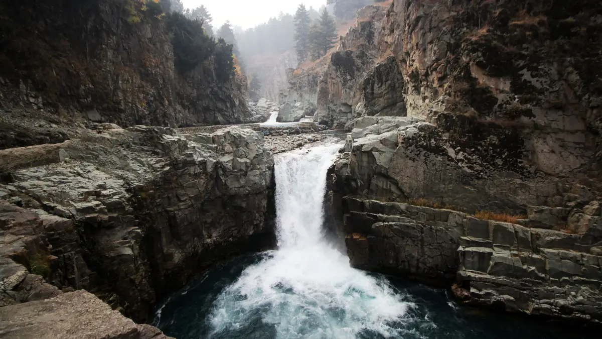
SRINAGAR: The Aharbal Waterfall in south Kashmir has migrated approximately 538 metres upstream over the past 57,000 years, with an estimated average retreat rate of 0.94 centimetres annually, according to a scientific study that has identified active tectonic forces, fractured bedrock and river erosion as the principal factors behind its changing landscape. The research also warns that the presence of geological faults, unstable riverbanks and landslide-prone slopes around the waterfall poses significant hazards, including the possibility of accelerated erosion, river blockage and, under extreme circumstances, the collapse of the waterfall.
The findings are part of a research paper, Climatic, Tectonic, and Fluvial Controls on the Origin and Retreat of the Aharbal Waterfall, Himalaya, published in fall of 2025 in the journal Results in Earth Sciences by Elsevier Inc.
The research is authored by Omar Jaan Paul, Reyaz Ahmad Dar and Shakil Ahmad Romshoo, whose work examines how the interaction of climate, geological movements and river erosion has shaped one of Kashmir’s prominent natural attractions. Omar and Dar are affiliated with the Department of Earth Sciences, University of Kashmir, Srinagar, and the Centre of Excellence for Glacier Studies in the Western Himalaya at the University of Kashmir. Romshoo is also affiliated with the same two institutions.
The study represents the first attempt to scientifically reconstruct the origin and quantify the retreat rate of a waterfall in the Himalayas. Its findings suggest that what appears to be a relatively stable natural feature is, in geological terms, a constantly evolving landscape.
Ancient Origins
Located approximately 75 kilometres south of Srinagar, Aharbal Waterfall is formed along the Vishav River in the Pir Panjal Range. The river originates in the southwestern slopes of the range and eventually joins the Jhelum near Sangam.
The researchers explain that the waterfall did not originate through a sudden geological event. Rather, it developed gradually as the river eroded the layers of glacial deposits covering the underlying rock formations.

During the glacial period, glaciers transported and deposited enormous quantities of unconsolidated material, commonly called glacial till, across the landscape. As glaciers retreated, the Vishav River increasingly took over the task of reshaping the terrain, cutting through these deposits until it encountered the much harder underlying volcanic rocks.
These rocks, comprising predominantly basalt and agglomeratic slate, belong to the Permian-age Panjal volcanic formations.
The exposure of the underlying rocks created differences in the resistance offered by different sections of the riverbed. This helped establish a steep drop in the river’s course, eventually producing the waterfall.
The researchers describe Aharbal as a structural knickpoint. In simple terms, a knickpoint is an abrupt change in the slope of a riverbed, often appearing as a waterfall or a steep cascade.
Unlike a waterfall formed by a sudden obstruction, a structural knickpoint is strongly influenced by the geological characteristics of the underlying rocks.
Retreat History
Using field observations, geological mapping and drone-based surveys, the researchers reconstructed five successive positions of the waterfall, from its original location to its present position.
Their analysis suggests that the waterfall initially developed approximately 538 metres downstream of where it stands today.
The researchers divided its upstream migration into different stages, identifying evidence of former waterfall positions through smaller cascades, plunge pools and other geological features along the river.
The first recorded stage involved a retreat of approximately 239 metres, estimated to have taken around 25,400 years.
The next stage involved an additional movement of approximately 151 metres, taking the cumulative retreat to 390 metres. This phase is estimated to have lasted around 16,000 years.
A further retreat of approximately 71 metres brought the cumulative movement to 461 metres, with this stage estimated to have taken around 7,500 years.
The remaining distance brings the total upstream migration to approximately 538 metres.
Based on the calculated average retreat rate, the researchers estimate that the waterfall took approximately 57,200 years to migrate from its original location to its present position.
The study notes that the migration may not have occurred at a uniform pace. The removal of large blocks of fractured rock can cause sudden advances in retreat, while ordinary river erosion may produce much slower changes.
Erosion Forces
The estimated retreat rate of 0.94 centimetres annually is particularly significant because waterfalls formed in basaltic rocks generally retreat very slowly.
The paper points out that retreat rates in basalt are normally less than one millimetre annually. Aharbal’s estimated rate is therefore considerably higher than what would ordinarily be expected from the erosion of such resistant rocks.
The researchers attribute this difference primarily to the extensive fractures and joints within the underlying rock formations.
The rocks around the waterfall contain three prominent sets of joints, which are essentially natural fractures or weaknesses within the bedrock.
One set consists of nearly horizontal fractures dipping upstream at approximately 10 degrees. Another runs almost vertically across the river, while a third intersects the other two at different angles.
The intersecting fractures create triangular and cubic blocks of rock that can become detached under the combined influence of flowing water and gravity.
As water continuously strikes the rock face, it exploits these natural weaknesses, loosening and removing blocks. Their removal allows the waterfall to move further upstream while maintaining its steep vertical appearance.
The researchers explain that the process is not simply one of water gradually wearing away solid rock.
Rather, the removal of an individual fractured block can sometimes produce considerably more retreat than prolonged ordinary erosion.
The study also identifies differences between freshly exposed and weathered rocks. Using a Schmidt hammer, an instrument that estimates rock strength through repeated impacts, the researchers recorded average strength values of 70.91 MPa for fresh basalt and agglomeratic slate formations and 65.75 MPa for weathered rocks.
The difference demonstrates how weathering reduces the resistance of rocks to erosion, making older exposed surfaces more vulnerable to the action of water.
Tectonic Activity
The research places Aharbal within the broader geological context of the Pir Panjal Range, one of the tectonically active mountain systems of the northwestern Himalayas.
The range is experiencing an estimated average uplift of approximately 10 millimetres annually, driven by the continuing interaction between the Indian and Eurasian continental plates.
Such geological movements influence river gradients, fracture patterns and the stability of mountain slopes.
To understand the extent of tectonic influence around Aharbal, the researchers examined two geomorphological indicators: the stream-length gradient index (SL) and the channel steepness index (Ksn).
These scientific measurements help identify unusual steepness and changes in river profiles that can indicate tectonic disturbances, variations in rock resistance and accelerated erosion.
The SL values calculated for 15 sections of the Vishav River ranged from 37.5 to 669.5. Particularly high values were recorded in sections close to Aharbal and the Balapora Thrust Fault.
The section encompassing the waterfall recorded an SL value of 607.5.
Similarly, the Ksn values across the Vishav basin ranged from 10 to 290, with higher values concentrated around the Aharbal reach and extending several hundred metres downstream.
The researchers interpret these patterns as evidence of enhanced river incision and tectonic influence in the area.
The paper also identifies the Balapora Thrust Fault as an important geological feature influencing the river’s course and the development of steep river sections.
Glacial Legacy
The study also establishes a connection between the present geological instability around Aharbal and the region’s glacial history.
The researchers identified several features associated with former glacial activity, including glacial striations, large transported boulders and roche moutonnée formations.
Roche moutonnée refers to distinctive rock formations shaped by moving glaciers, which smooth one side while leaving the other relatively steep and rugged.
These features indicate that glaciers once extended down to the Aharbal area and played an important role in shaping the Vishav River valley.
During periods of glacial advance, the weight of the ice and the accumulation of glacial deposits exerted pressure on the underlying rocks. As the glaciers retreated, the removal of this pressure contributed to the development and expansion of fractures.

The researchers suggest that this process of glacial loading and unloading, combined with the natural cooling and contraction of volcanic rocks, contributed to the extensive jointing observed around the waterfall.
Subsequent river erosion exploited these weaknesses, progressively cutting into the exposed bedrock and encouraging the waterfall’s upstream migration.
The study therefore identifies Aharbal’s present landscape as the product of a long interaction between glacial processes, tectonic movements and river erosion.
Geological Hazards
While the study reconstructs the waterfall’s geological evolution, its most significant findings concern the potential hazards in the surrounding area.
The researchers document several indications of instability along the banks of the Vishav River, including faults crossing the river course, fractured rocks, dislocated retaining walls, road subsidence and evidence of gradual ground movement.
A fault was identified just a few metres upstream of the waterfall. The researchers observed highly sheared rocks along this feature, with its traces extending across both sides of the river.
They also documented dislocation of retaining walls and the movement of surrounding ground towards the waterfall.
Another indication of instability is the presence of landslides along inferred fault lines near the river.
The researchers, however, clarify that the observed landslide is not direct evidence of active faulting. It nevertheless highlights the geomorphological instability of the area.
The combination of geological weaknesses and tectonic activity could make the surrounding slopes particularly vulnerable to further failures.
The paper warns that earthquakes or other sources of ground shaking could aggravate these conditions. Water-filled cracks and existing fractures can reduce the strength of the rocks, potentially triggering the detachment of large blocks.
Such failures could accelerate the waterfall’s retreat or cause substantial structural damage to the waterfall itself.
The researchers also identify the possibility of river blockage, backwater formation and outburst floods as potential consequences of large-scale slope failures.
A blockage caused by falling rock or landslide material could obstruct the river, resulting in water accumulation upstream. A subsequent sudden release could create dangerous downstream flooding.
Urgent Monitoring
The researchers conclude that the geological processes shaping Aharbal are continuing and that the waterfall’s stability cannot be assessed independently of the surrounding mountain slopes and riverbanks.
They recommend comprehensive geotechnical investigations, continuous monitoring of geological hazards and targeted mitigation measures to protect the waterfall and its surrounding infrastructure.
The study stresses that the presence of active faults and structurally weakened rocks makes the area particularly vulnerable to future instability, especially in the event of a major earthquake or large-scale slope failure.
It also cautions that such events could significantly accelerate the waterfall’s retreat and, in extreme circumstances, lead to its catastrophic collapse.
The researchers argue that monitoring should extend beyond the waterfall’s immediate location to include the surrounding slopes, fault systems and riverbanks.
The findings have implications beyond the preservation of a tourist attraction. Aharbal is an important geological feature that offers evidence of the long-term evolution of the Pir Panjal landscape.
The authors emphasise that understanding its retreat is important for assessing landscape changes and developing appropriate hazard mitigation strategies in this tectonically active Himalayan region.