Research reconstructs a massive Jhelum blockage that submerged large parts of Kashmir Valley, questions conventional dating of the disaster and attributes damage to medieval temples partly to historical earthquakes rather than vandalism
SRINAGAR: A major research paper published in Bulletin of Earthquake Engineering has reconstructed a catastrophic earthquake-induced landslide and flood in ninth-century Kashmir, concluding that the disaster which submerged large parts of the Valley probably occurred before 855 CE, rather than in 883 CE, the date traditionally associated with it.
The researchers argue that the earthquake triggered a landslide near Baramulla, blocking the River Jhelum and creating a vast lake that extended southwards towards Bijbehara. Their calculations suggest that the Valley would have taken at least two years to fill to the recorded flood level, making the traditionally accepted date of 883 CE chronologically difficult to sustain.
The study also challenges established explanations for the damaged condition of Kashmir’s medieval stone temples. It argues that earthquakes over several centuries caused substantial structural damage, including the displacement and collapse of massive stone blocks, which historians and archaeologists have frequently attributed to deliberate destruction by successive rulers and religious groups.
The research, A ninth century earthquake-induced landslide and flood in the Kashmir Valley, and earthquake damage to Kashmir’s Medieval temples, was conducted by Roger Bilham of the Department of Geological Sciences, University of Colorado, Boulder, USA, and Bikram Singh Bali of the Department of Geology and Geophysics, University of Kashmir.
Published by Springer in Bulletin of Earthquake Engineering (Volume 12), the paper was published in August 2013.
The research combines historical accounts from Kalhana’s Rajatarangini and Pir Ghulam Hassan Khuihami’s Tarikh-i-Hassan with geological observations, historical river-discharge records, archaeological evidence and radiocarbon dating.
The Great Flood
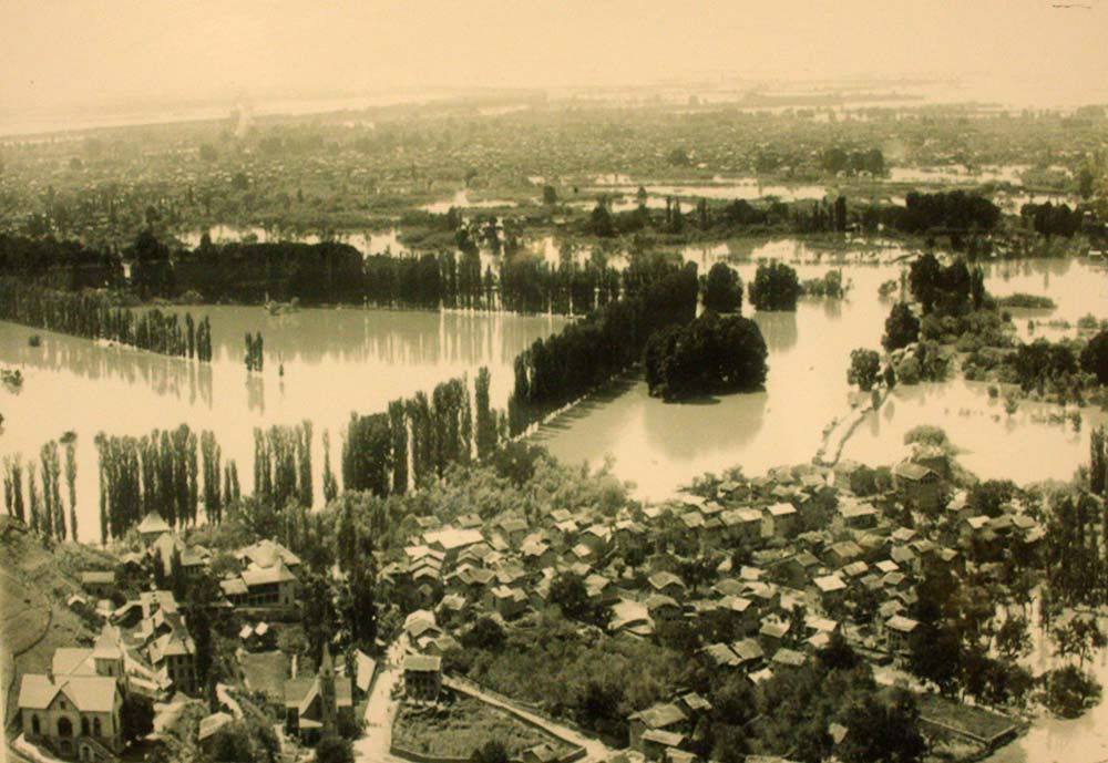
The study revisits an account of a devastating flood during the reign of King Avantivarman (855-883 CE). According to Tarikh-i-Hassan, an earthquake at night caused a portion of a mountain ridge near Khadanyar, on the Baramulla side, to collapse into the Jhelum. The resulting natural dam blocked the river, causing water to accumulate across the Valley and inundate villages and agricultural land as far as Bijbehara.
The paper reproduces the historical account describing how the earthquake caused boulders from the mountainous ridge of Khadahneyar to roll into the river, blocking its flow. The account says that villages and cultivable land near Bijbehara were destroyed before the obstruction was eventually removed through the intervention of Suyya, the engineer associated with Avantivarman.
The researchers identify the likely landslide zone in the Jhelum gorge downstream from Baramulla, where the river passes through a narrow channel surrounded by steep and unstable mountain slopes.
Their geological assessment identifies several possible landslide locations along this stretch, particularly around Khadanyar and Gantamulla.
The significance of the location is that the Jhelum has a relatively narrow passage through the gorge before leaving the Valley. A landslide capable of blocking this channel could create a natural reservoir, with water progressively accumulating across the Kashmir basin.
The researchers calculate that a natural dam with a crest approximately 10-30 metres above the existing river channel could have inundated extensive low-lying areas of the Valley.
Two-Year Flooding
One of the most important findings concerns the time required for the Valley to fill.
Using historical discharge statistics of the Jhelum recorded during the twentieth century, the researchers calculated how quickly water would accumulate behind a natural dam downstream of Baramulla.
They found that filling the Valley to the level of Bijbehara, approximately 17 metres above the normal level at which the Jhelum exits the Valley, would require at least two years under typical river-discharge conditions.
The calculations also indicate that when floodwaters reached Bijbehara, Srinagar would have been submerged to a depth of approximately five metres.
The researchers used observed discharge figures at Baramulla, where the annual mean discharge between 1922 and 2000 was approximately 237 cubic metres per second. The river experiences considerably higher flows during the April–July snowmelt season.
Even under favourable discharge conditions, the process of filling such a large basin would have taken considerable time.
The paper explains that a landslide dam formed in December, when river discharge is relatively low, could take approximately 200 days to raise the water level by the first 10 metres. During the April snowmelt season, the same rise could take roughly half that time.
However, as the flooded area expanded, the rate of accumulation would slow because of the increasing volume of water required to raise the lake level further.
The authors write that their calculations make it impossible for the Valley to have filled to Bijbehara and subsequently been drained within the final months of Avantivarman’s reign.
Date Questioned
The chronological problem is central to the research.
The earthquake and resulting flood have traditionally been associated with 883 CE, the final year of Avantivarman’s reign. However, the king died in March that year, when river discharge was normally low.
The researchers argue that a flood of the magnitude described in historical accounts could not have developed, reached Bijbehara and then been drained within the remaining months of his reign.
They also calculate that draining the accumulated floodwaters would have required several additional months. Even assuming a sustained discharge of approximately 1,000 cubic metres per second, emptying the Valley would have taken around six months.
The researchers therefore propose that the flood already existed when Avantivarman ascended the throne in 855 CE.
They suggest that the disaster may have occurred during the reign of an earlier ruler, possibly Ajitapida, although the historical record does not provide sufficient evidence to establish the identity of the ruler or the precise date of the earthquake.
The authors also question whether the earthquake mentioned in Tarikh-i-Hassan and the flood described in Rajatarangini were two separate events.
They suspect that Khuihami may have incorrectly associated the earlier disaster with Avantivarman’s final year, while actually referring to the same flood described by Kalhana.
The paper states: “We conclude that Avantivarman inherited a flood at, or soon after, the time he ascended the throne in 855 CE.”
Suyya’s Engineering
The researchers devote considerable attention to the engineering intervention attributed to Suyya, whose work is described in the fifth book of Kalhana’s Rajatarangini.
According to the historical account, Avantivarman offered Suyya the resources required to drain the Valley. Instead of immediately undertaking construction, Suyya reportedly threw pots of the king’s money into the floodwaters, attracting villagers who were desperate to retrieve the coins.
The exercise brought labourers to the river, where they began removing the stones obstructing its flow.
Kalhana describes how Suyya first reduced the water level, subsequently blocked the river temporarily with a stone structure, cleared and strengthened a channel through the obstruction, and finally removed the temporary dam to allow the rushing water to enlarge the channel.
Bilham and Bali interpret this account as a sophisticated engineering operation involving several stages.
These included the initial removal of debris, construction of a temporary coffer dam, excavation and lining of a spillway, and finally the destruction of the temporary dam to generate sufficient hydraulic force to clear the remaining landslide material.
The researchers estimate that the final drainage of the Valley may have taken between two and six months.
They also point out that the work attributed to Suyya extended well beyond removing the natural obstruction.
Irrigation Revolution
Following the drainage, Suyya is credited with undertaking extensive hydraulic engineering across Kashmir.
Kalhana describes the construction of diversion channels, embankments, irrigation canals and flood-protection structures.
Among the projects mentioned is a 67-kilometre stone-lined embankment along the Jhelum, alongside the construction of overflow channels, drainage of wetlands and flood defences around vulnerable villages.
Suyya also reportedly altered the courses of rivers near Parihasapura and established new channels around the confluence of the Jhelum and Sindh rivers.
The researchers observe that the scale of these projects would have required enormous financial resources and manpower, even by modern standards.
They suggest that the reclamation of flooded agricultural land and the expansion of irrigation helped transform the Valley’s economy during Avantivarman’s reign.
Kalhana’s account provides an economic dimension to this transformation.
The price of rice, which had reportedly reached 1,050 Dinnaras per khari during the difficult period preceding Avantivarman, fell to 36 Dinnaras during his reign.
One khari was approximately 88 kilograms.
The researchers interpret this dramatic decline as evidence of the agricultural recovery associated with drainage and irrigation works.
They also note that Kalhana attributed the establishment of numerous new settlements to the reclamation of land following the flood, although the claim of thousands of settlements may have been exaggerated.
Temples Beside Lake
An important archaeological implication of the proposed flood is its possible relationship with the construction of Kashmir’s medieval temples.
The researchers mapped ten major limestone and stone-monolith temples against the inferred shoreline of the ancient lake.
They found that seven of these temples were located close to the 1,600-metre elevation contour, corresponding approximately to the reconstructed flood level.
The positioning of these structures raises questions about how enormous building materials were transported across the Valley.
Many of Kashmir’s medieval temples were constructed using massive, carefully dressed limestone blocks assembled without cement. Some individual blocks measured approximately one metre by one metre by three metres, while others measured three metres by three metres by one metre.
The researchers estimate that some of these blocks weighed more than nine metric tonnes.
They propose that the existence of a large temporary lake could have facilitated the movement of such materials by barges from distant quarries and construction sites.
The possibility is particularly relevant to temples situated away from the present course of the Jhelum.
However, the researchers are careful not to present this transportation hypothesis as established fact.
Their investigation of the Sugandhesa temple at Patan did not produce sufficient evidence to establish when the building materials were transported or whether they were actually carried by water.
They conclude that the proposed barge transportation remains unsubstantiated.
Earthquake or Vandalism?
The second major aspect of the research examines the physical damage to Kashmir’s medieval temples.
The authors challenge the conventional explanation that the ruined condition of many structures resulted primarily from deliberate destruction by subsequent rulers.
Historical accounts have frequently associated the destruction of temples with Sultan Sikander (1389-1413), popularly known as Sikander Butshikan, and the alleged systematic demolition of Hindu and Buddhist religious structures.
The researchers argue that several patterns of structural damage are more consistent with earthquake shaking than deliberate dismantling.
They draw attention to the lateral displacement of stone blocks within temple walls, the shifting of massive roof stones and the displacement of architectural elements without corresponding destruction of the lower foundations.
Such damage, they argue, is characteristic of prolonged earthquake shaking.
The paper also notes that medieval Kashmiri architects constructed temples using interlocking stone blocks of different sizes and shapes. The structures did not employ conventional segmented arches but frequently used large horizontal stone beams supported by pillars.
This construction method gave many temples considerable resistance to moderate shaking.
The researchers argue that earthquake damage often occurred incrementally, with blocks becoming dislodged from the upper portions of structures while lower sections remained relatively intact.
They do not deny that deliberate destruction occurred. Instead, they suggest that the extensive survival of structural masonry, despite the damage visible in many temples, warrants a more careful examination of the role of earthquakes.
They also point out that the removal of stone materials from abandoned temples may have taken place after earthquakes had already reduced otherwise intact structures to piles of dressed masonry.
Three Temples
The researchers examine several temples to establish the physical characteristics of earthquake damage.
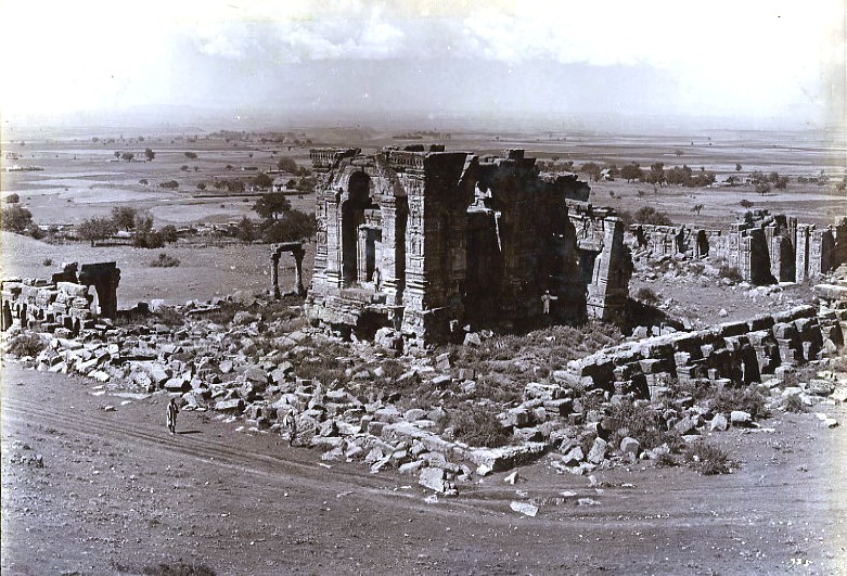
At Pandrethan, approximately three kilometres east of Srinagar, the Shiva temple has suffered displacement of roof blocks and loss of its capstone.
The authors compare historical photographs and conclude that some of the displacement occurred before the 1885 earthquake.
The Payar temple provides another example. Its massive roof stone has shifted laterally by approximately seven centimetres.
Earlier archaeologists interpreted the displacement as evidence of an unsuccessful attempt to dismantle the structure.
Bilham and Bali argue that the movement is more consistent with earthquake-induced lateral displacement.
At Naranag, both the upper and lower temple structures have lost their massive monolithic stone roofs. The authors note that subsequent restoration efforts have replaced some of the smaller masonry blocks, but the enormous roof stones remained displaced.
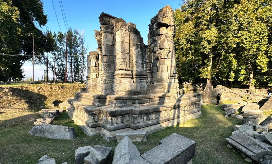
They also examine the Sankaragaurisvara and Sugandhesa temples at Patan, both of which suffered damage during the 1885 earthquake.
Historical photographs from 1868 and subsequent images provide evidence of the changing condition of these structures.
Sugandhesa Investigation
The most detailed archaeological investigation was undertaken at the Sugandhesa temple near Patan.
The researchers selected the site because it offered an opportunity to examine the relationship between fallen stone blocks and the soil layers beneath them.
Their objective was to establish whether radiocarbon dating of charcoal and other material trapped beneath fallen blocks could help identify the dates of historical earthquakes.
The investigation was facilitated by debris removal undertaken by the Archaeological Survey of India in 2010.
The researchers excavated six small pits around the western side of the temple, collecting samples from different layers of soil and construction material.
Rather than moving the massive stone blocks, they excavated small inclined pits beneath them to establish the stratigraphy and retrieve material for dating.
Radiocarbon analysis was used to establish the approximate ages of charcoal samples.
The results confirmed, with 95 per cent confidence, that construction of Sugandhesa had started by 889 CE.
Historical accounts place its construction during the reign of King Samkaravarman (883-902 CE), who established his capital at Patan and named the temple after his queen, Sugandha.
The researchers found that the radiocarbon evidence was consistent with the historical construction period.
However, they could not establish the precise date when the enormous stone blocks were transported to the site.
They also found evidence suggesting that construction may have remained unfinished. Some decorative elements were incomplete, while a collection of dressed stones near the temple may have been intended for further construction.
Earthquake of 1123
The investigation produced another significant finding concerning the damage to Sugandhesa.
The researchers examined a fallen stone block whose position and surrounding soil deposits indicated that it had been displaced by earthquake shaking.
They associated its collapse with an earthquake in 1123 CE mentioned briefly by Kalhana.
The historical reference describes the sun blazing fiercely, repeated trembling of the earth and destructive winds that brought down trees and boulders.
The researchers found that the fallen block was covered by a later clay deposit, allowing them to establish a broad chronological relationship between its collapse and the subsequent accumulation of sediment.
They caution that the dating is not precise because the study examined only a limited portion of the temple.
Nevertheless, they consider the evidence consistent with earthquake damage during the twelfth century.
The researchers also examined historical photographs of Sugandhesa taken in 1868.
Using the estimated accumulation rate of sediments around the temple, they suggest that some blocks visible in the photographs may have fallen approximately 200 years earlier.
This raises the possibility that an earthquake during the seventeenth century, potentially the events recorded in 1669 or 1736, caused additional damage.
They find no evidence that the temple suffered the particular collapse examined in their study during the major earthquake of 1555, traditionally regarded as one of the most destructive earthquakes in Kashmir’s recorded history.
The 1885 Earthquake
The study also documents the effects of the earthquake of May 30, 1885, on Kashmir’s medieval temples.
Historical photographs and accounts indicate that the Sankaragaurisvara temple at Patan suffered substantial damage, including the collapse of its central trefoil portal and the loss of stone blocks from the upper portions of its structure.
The Sugandhesa temple also sustained damage.
The authors use the historical record to establish that earthquake shaking continued to affect these structures long after their original construction.
Their examination reinforces the argument that the ruined condition of Kashmir’s medieval temples cannot be explained through a single episode of deliberate destruction.
Instead, successive earthquakes may have contributed to their gradual deterioration over several centuries.
Archaeological Warning
The researchers raise concerns about the loss of archaeological evidence through earlier excavation and restoration activities.
They point out that archaeologists frequently moved massive temple blocks without documenting the soil and sediment layers immediately beneath them.
These layers, they argue, contain valuable evidence that can help establish when a particular block collapsed and whether its displacement was caused by an earthquake.
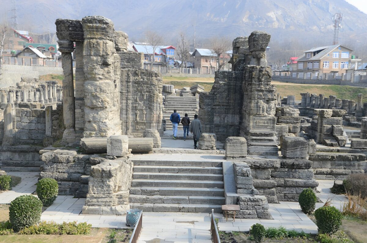
The researchers observe that extensive disturbance at Martand, Avantipur, Naranag and several other archaeological sites has destroyed opportunities to conduct similar investigations.
They describe the undisturbed northern portion of Sugandhesa as a particularly important archaeological resource.
The authors argue that further excavation and radiocarbon dating at this location could help establish a more reliable chronology of historical earthquakes in Kashmir.
They conclude that the study demonstrates the potential of combining archaeological stratigraphy with radiocarbon dating to reconstruct earthquake histories in regions where instrumental seismic records are unavailable.
Seismic Vulnerability
The paper ends by drawing attention to the continuing geological vulnerability of the Kashmir Valley.
The authors argue that the ninth-century disaster should not be viewed as an isolated historical event.
The Jhelum exits the Valley through a narrow gorge surrounded by unstable mountain slopes. Earthquakes can trigger landslides in this terrain, potentially creating natural dams capable of blocking the river.
Even a relatively modest obstruction, they warn, could produce extensive flooding because of the geography of the Valley.
The paper also revisits historical accounts of an earlier flood around 1250 BC, which reportedly submerged a settlement near present-day Wular Lake and inundated areas between Khadanyar and Bijbehara.
The authors suggest that geological evidence of earlier floods may still be preserved beneath the accumulated sediments of the Valley.
Their broader conclusion is that the history of Kashmir’s floods, earthquakes and temple construction is interconnected, and that geological investigation can help resolve questions that have remained uncertain in historical accounts for centuries.
The research ultimately identifies the undisturbed archaeological deposits around Sugandhesa as an unusually valuable opportunity for further investigation into Kashmir’s historical seismic activity.