
by Mir Sajad
The subject of Geography has often been understood and considered as the Gazetteer with names of countries and information about them but this stream of knowledge has turned out to be the most important addition to our meaning and metaphors of our daily life from driving a car to identifying the critical hotspots or clusters of any disaster. ‘Space’ forms the kernel and core of geographical knowledge thus encompassing the phenomenon of the body politic and social fabric in its entirety.

In contemporary times with emerging paradigms of ‘space episteme’, this intersection and contestation of topos with the active political space in the public discourse have been righty epitomized by Edward Soja as “spatial turn” of this century. The world has changed drastically in the spheres of climate, production, consumption and behavioural patterns with the imbalances and negative feedbacks being observed in the environment which prompted some scientists to propose present epoch as “Anthropocene” Geography studies this changing interaction of the environment with the human responses in its comprehensive theoretical and scientific mechanism and subsequently modelling the impacts and patterns of this dynamic trend. Diffusion of diseases and the related outbreaks have also been modelled and the pathways tracked thus helping the world and regional health agencies framing policies an strategies for mitigating the impact and spread of diseases. As currently, the world has been in the grip of deadly and sporadic pandemic disease named by WHO as COVID-19 and the virus as severe acute respiratory syndrome Coronavirus 2 (SARS-CoV-2) by International Committee on Taxonomy of Viruses(2020), geographical knowledge coupled with the temporality of the incidence and spatial prevalence of this global health threat has proved to be the guiding light amidst the dark frontiers of novel epidemiological characters of this outbreak
Geospatial Science and Public Knowledge
In this age of big data, the need of “Big Geospatial Data” becomes equally important given the complexities and dynamic nature of biophysical and social interfaces. In the same vein geospatial knowledge has helped in the real-time information delivery and public understanding of Coronavirus spread around the world. Most of the geospatial data platforms have been in the forefront currently for the data visualization, monitoring and concurrently its reach to the common people at any place of the world and any time. WHO has provided the situational dashboard updated every 15 minutes providing a real-time perspective for officials and users with the easy-to-view visual interface using Geographical Information System (GIS Science) on region and casewise spread.
The enhanced and sophisticated real-time information can be viewed through the Environmental Systems Research Institute (ESRI). ESRI Disaster Response Program and ESRI’S ArcGIS Hub including the in-depth information from various operational dashboards with interactive data view providing key understanding and monitoring of global and feature datasets related of the virus and public knowledge.
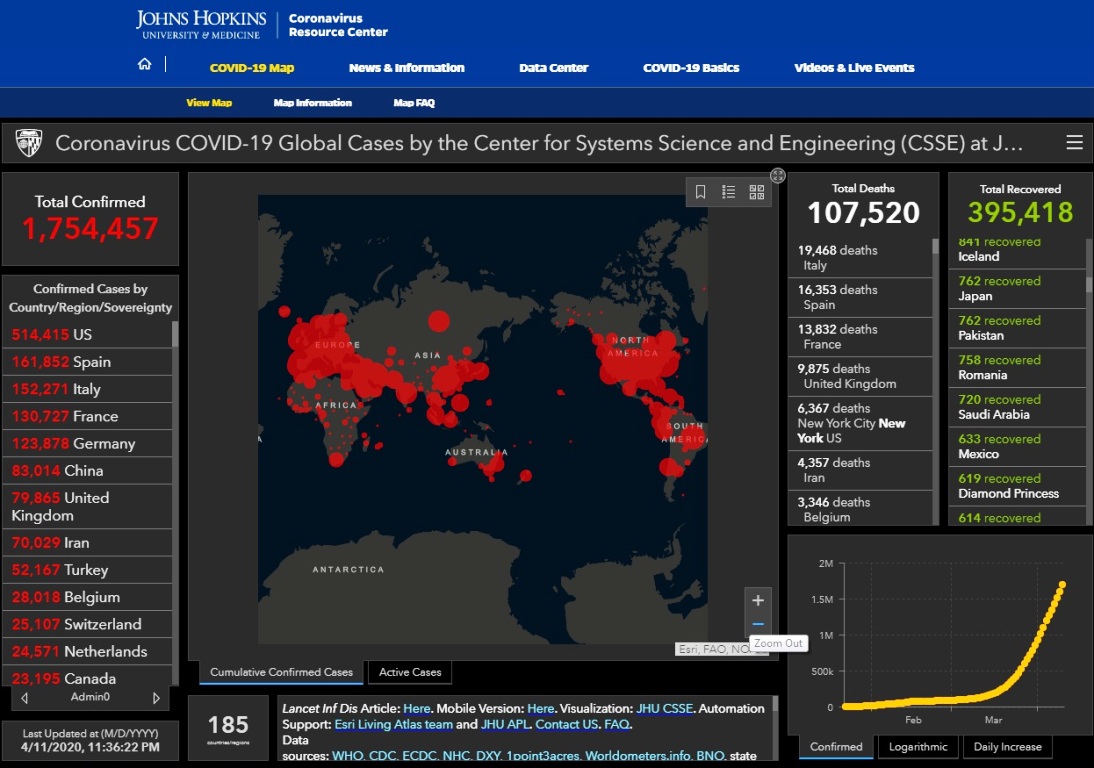
Other platforms were the expert epidemiological analysis of COVID-19 hyphenated with the public health analytics has been maintained by Center for Systems Science and Engineering at Johns Hopkins University (JHU) with its GIS operational setup mapping the similar trajectory in real-time. Below is the snapshot of the site:
In India MapmyIndia Maps and Move app is enabling users to locate, view and reach testing labs nearby and subsequent isolation and treatment facilities. Users can have the firsthand account of the facilities and can add reviews of the centres there and helping other users with updated and critical knowledge regarding the conditions and status of quarantine and isolation facilities MapmyIndia resources are designed for early detection and isolation of infected persons which are crucial in respect of spread of this disease.
With the use of this metadata and imagery creating a robust GIS and comprehensive geo-databases in an analysis-ready format thus opening a new path for redefining epidemiological studies in concert with the pathways and vector-based differentiations across the world. With the use of data mining and machine learning algorithms like Python and Anaconda with the integration of geographical knowledge, it can help us in the accurate and reliable prediction of threats and stresses whether related to health or environment. Google Earth Engine uses this algorithm based geographical and environmental variables for predicting and subsequently providing effective management strategies for the better and sustainable biophysical and social environment.
Critical Geographies and Coronavirus
There has been an overarching ‘complexity turn’ within the geographical studies and it forms the essential pivot when it comes to the health landscape of any region as put forward by Anthony Gatrell. This has turned out to be the potential paradigm for social sciences having transformed much of physical and biological sciences with the dissolution of binary divides whether media/socio-cultural, structure/ agency, institutional /individual, environment/social etc..There is an immediate need to move beyond the traditional epistemes of geographical analysis and to explore further the added value of critical geographies for our research in health inequalities, disease ecology, and spatial diffusion. Many examples of critical geographies can be cited from the fact that institutions, organisation and governments have undermined the character and configurations of ‘geography’ when it comes to health infrastructure and individual healthcare facilities thus coronavirus has laid bare the response and system of the approach of countries around the world. There are widespread inequalities when it comes to the healthcare geographies around the world, thus arising a need for the global and uniform approach of healthcare governance in consonance with the changing contours of political and economic landscapes around the world. Critical geographies deconstruct the hegemonic geographies of the world in the lens of radical perspective and the consequent geo-economic and geopolitical undercurrents which is needed for the current disarrayed healthcare system of the world. At last, keep resisting the virus and the injustices around your geographies.
( The author is a doctoral Fellow, Health and Groundwater Studies, Department of Geography, University of Kashmir. Ideas expressed are personal.)


