by Faisal Kawoosa
AI simulations expose hidden inequities in Srinagar’s new building bylaws, demonstrating why predictive policy testing should precede implementation.

As a data analyst, my everyday workspace is built around system architectures, algorithmic validation, and combinatorial verification. I am not a town planner, an urban designer, or a civil engineer. However, what I know deeply is that public policy is simply legal code pushed into production.
In the technology sector, before launching any product that influences millions of users, simulations and other testing techniques are used to identify inconsistencies and evaluate the efficacy of the parameters defined for users, especially in a self-service model.
When the Srinagar Municipal Corporation recently announced its new residential building bylaws, the official notification appeared entirely logical. At a surface-level reading, the reforms seemed balanced and well considered. It aimed to relax regulations gracefully across three basic property tiers. But reading a legislative text like a standalone press note misses the hidden mechanics. When treated as an interacting network of spatial variables, the systemic discrepancies immediately emerge.
To systematically test the equity and performance of these new rules, I did not rely on intuition or guesswork. I explicitly leveraged AI paired with geometric modelling to run a comprehensive combinatorial simulation of the bylaws. What the data revealed is a textbook warning of how traditional policymaking can inadvertently penalise citizens and create critical structural imbalances rather than bringing the intended ease.
The Boundary Collision

The newly introduced framework creates three separate structural parameters based strictly on property size:
Plots up to 10 Marla: Granted the privilege to build a single “blind wall” directly flush against a neighbour’s property boundary.
Plots between 10 Marla and 1 Kanal: Bound by a strict, mandatory 5-foot safety setback or fire-gap buffer on all sides.
Plots above 1 Kanal: Permitted to cover up to 90 per cent of their total land area with a permanent concrete footprint, a massive leap from the historical 40 per cent restriction.
Independently, each of these updates can be reasonably justified. But our cities do not exist in isolated brackets; they are organic, mixed environments.
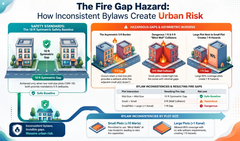
When a typical mixed residential block was simulated, where these property tiers sit side by side, the physical distance available for emergency fire protection shifted dramatically. Safety margins and building requirements became dependent purely on the random circumstance of who a citizen’s immediate neighbours happened to be.
As illustrated in the streetscape simulation, a walk down a single lane exposes a highly erratic safety gradient:
0 ft: Where two sub-10 Marla properties both exercise their right to build blind walls.
5 ft: Where a small plot’s blind wall meets a mid-sized plot’s mandatory setback, placing the entire regulatory, environmental and physical safety burden on one owner.
10 ft: Where two mid-sized plots sit adjacent, each respecting its mandatory 5-foot setback.
A hazardous 1 ft: An edge-case pairing where a small blind-wall house sits directly beside a one-Kanal-plus structure utilising its 90 per cent footprint allowance.
The one-foot pairing highlights a complete policy inequality. The largest, heaviest and most fire-loaded building type on the block, simply because it may occupy 90 per cent of a massive parcel, is legally allowed to crowd its neighbour with the narrowest separation margin on the entire street. This occurs because the regulation completely overlooks any side-margin restriction for large plots. The system remains silent precisely where real-world risk is greatest.
The Crossover Trap
The deeper equity discrepancy becomes evident when examining the raw density calculations. Intuition may lead a casual reader to assume that larger plots naturally leave significantly more open ground than smaller plots. To verify this assumption, a linear-versus-quadratic growth simulation was executed using the exact parameters contained in the bylaws.
The mathematical mismatch stems from the way the two tiers scale:
The Perimetric Tier (up to 10 Marla): Unbuildable space is determined by fixed-width boundary strips at the front, rear and sides. The deduction scales linearly with the perimeter.
The Proportional Tier (above 1 Kanal): Unbuildable space is fixed at 10 per cent of the total plot area, growing quadratically with total area.
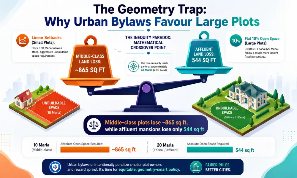
Because linear progression eventually intersects a quadratic curve, the regulations create a striking geometric anomaly when plotted continuously.
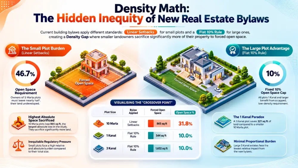
When the data are examined, the disparity becomes unmistakable. A middle-class homeowner building on a maximum-tier 10-Marla plot is legally required to surrender roughly 865 square feet of land to mandatory open space.
Meanwhile, an affluent landowner constructing a large residence on a one-Kanal plot under the flat 10 per cent rule is required to leave only 544 square feet unbuilt.
The structural inequity is evident. A family constructing a standard 10-Marla house is legally compelled to sacrifice more absolute land area to the city’s open environment than a wealthier property owner building on a plot twice the size.
The simulation further shows that a plot must exceed approximately 2.05 Kanal (about 41 Marla) before it is required to leave more open land than a standard 10-Marla plot. This represents a significant regulatory distortion, creating a powerful incentive for land consolidation above one Kanal while disproportionately penalising smaller, middle-class property owners.
Upstream Simulation
Detecting these discrepancies did not require expensive geographic information systems or specialised enterprise software. It simply required treating municipal regulations as an interconnected system with moving variables and testing them before deployment.
This is precisely the type of exhaustive, case-by-case scenario testing that AI, combined with straightforward mathematical modelling, performs exceptionally well, and that human committees working in isolated bureaucratic silos frequently overlook.

This case study should redefine how AI is understood in governance. The principal value of artificial intelligence in public administration is not the creation of chatbots that respond to citizens after policy failures occur. Its greatest value lies upstream: using predictive simulation models to debug, stress-test and refine laws before they are translated into concrete, brick and mortar for generations.
The Srinagar Municipal Corporation undoubtedly drafted these guidelines with progressive developmental intent. However, because they were insufficiently tested, they have produced systemic inequities. To restore fairness, geographic symmetry and reliable fire safety, the municipality should revisit these guidelines. By subjecting such regulations to automated simulation before implementation, cities can identify structural imbalances and correct them before a single shovel enters the ground.
(Founder and Chief Analyst of Techarc, the author is a leading technology analyst and commentator who tracks and analyses emerging trends in the sector. Ideas are personal.)