
by Khursheed Wani
April has never been wet in two decades in a colossal way as this year in Kashmir. The cyclonic circulation induced by the western disturbances kept on hovering over the Valley’s skies, triggering profuse showers every time in one or the other corner. When the riot of colours began in the famed Tulip Garden in Srinagar, one of the largest such gardens in south Asia, the rain gods, turned hostile again like several previous years. A short week of continued downpour and the millions of flowers silently withered away without creating a flutter. An unusual layer of snow at the beginning of spring enveloped the entire city including the tulip carpets sprayed in the lap of Zabarwan hills overlooking the brimming Dal Lake. The Jhelum River flowed closer to the brink with its trademark majesty.
The winter was harsher with plenty of snow and bone-chilling cold wave. Kashmir remained cut-off for weeks and people confined to homes or short distances. The most anybody ventured out was to ski-resort of Gulmarg where winter is the best bet for hangouts. A trickle of enthusiasts stole the moments though I was not lucky this time.
Come spring, and everyone in Kashmir, native or not, has an eagerness to hit a hill station to break the winter monotony and rejuvenate by breathing some fresh air from the hills. This spring the sunshine was more tempting and the gang was, for a change, not ready to hit the trodden tracks. “Let’s go to a place we have never been to,” shouted Haroon and we began searching for the destination. A few phone calls to our friends in north Kashmir helped to zero in on Khodgu-Monglu hills in Sopore sub-division. It is yet another exclusive combination of lake and hills, something special to Kashmir. Wullar Lake, the largest freshwater lake in Asia, is visible from every observation point on these hills, emphasized Bilal, a Sopore resident and a mountain freak with the special interest in Kashmir’s flora and fauna.
On a misty April 20 morning, we began our journey on famed Srinagar-Muzaffarabad road, once the most important road-link to the outer world, now restricted to a few weekly cross-Line of Control bus and truck runs. The poplars grown majestically on both sides of the road, showcased in many Bollywood movies of the 1970s golden era, have either withered or chopped off. As we swished past the shrinking Hokera and Haigam wetlands, only a few migratory birds were seen taking flights. Maybe these are the last flights they took off this spring as most winged guests of their tribe have already left for their summer destinations as far away as Siberia and Afghanistan. Their aerial travel is not restricted.
An hour-long journey takes to Sangrama, a highway township where north Kashmir travellers split for their destinations. Straight travel leads to Baramulla and Uri and for entry into vast districts of Kupwara and Bandipora, a right turn towards historic Sopore town is required. We moved towards the right with Bilal’s advice in mind to avoid getting into traffic snarls inside the most congested and unplanned towns of the Valley, also known as apple town for its massive fruit produce. Fortunately, the town was beginning its day and horse-carts or tangas, now a rare site in Kashmir except in Sopore were not dominating the roads. We manoeuvred quickly and in half-an-hour, were out of the town and rich with Bilal’s company, on the road towards Bandipora and Gurez. The cool breeze emanating from Wullar Lake was quite refreshing.
The ascendance towards Khodgu-Monglu Mountain starts at Botengu, a village 10 kilometers from Sopore town. On the right side is Baba Shukruddin’s shrine atop a plateau overlooking the Wullar Lake. Thousands of devotees visit the shrine every year. A hotelier suggested paying obeisance at the shrine on our return from the mountains. We packed some food stuff before beginning our journey towards the mountains.
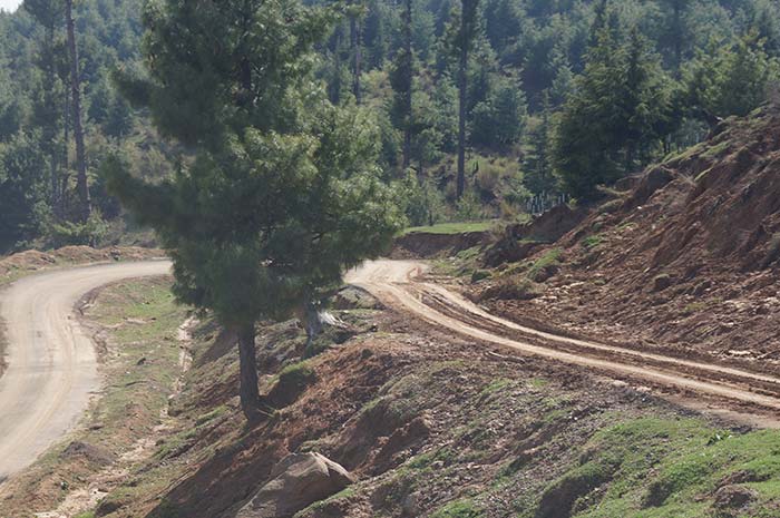
The challenging journey begins at the beginning. The movement our car embarked on the road, a 60-degree slope welcomed it. A few yards away, the road seemed to be ending but then appeared a widened curve and a parallel stretch. After every hundred years, the road gives birth to a new curve followed by another on the neatly macadamized road. No bumps and potholes are visible probably because the inclined road does not retain water. On the sides of the road, ascending the foothill, craftily pruned apple trees are seen in countless rows with their shiny branches ready to sprout the darling buds. Occasionally, a cab descended from the opposite side alerting our driver but mostly the journey was uninterrupted.
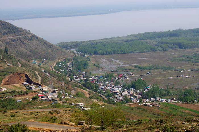
As we reached the middle of the mountain, the length between the road curves increased. On the sides appeared small plateaus dotted with green conifers. There are countless stumps of pine and cedar trees like a scalp facing hair loss for years. A few decades ago, a villager told us, the forests were very dense. The sunrays were shining the needle leaves of the conifers and never got a chance to kiss the earth. Now the silver rays also descend on the lifeless barks though the dense forest exists after every stretch. The conifers are standing everywhere, sometimes only inches from the road. We halted at a plateau, almost a kilometre up from the water level to watch the majestic Wullar Lake, now in front of our eyes with its massive expanse, framed all sides with green trees. The mirror images of snow-capped mountains surrounding the still lake offer a kaleidoscope of colours. The fishermen rowing in their canoes appears to be like dots moving on the water surface. It is soothing to watch birds aimlessly flying in the enormous space between the Wullar’s surface and the blue sky dotted with clouds. Their limit of flight is much lower than we have already attained at this observation point. The sight of Wullar Lake from various points on way to Hardu-Munglu is most rewarding. This face of Wullar, like a canvas spread by nature, cannot be viewed discreetly from any other place.
The arduous road snakes into the grove of conifers and every time offers an unexpected site. Hundreds of young pine trees are uprooted, some of them chopped and turned into logs on the roadside. A villager Muhammad Shaban says the forest encountered the unexpected and somewhat unprecedented devastation during the snowfall in the first week of April. “This was peculiar snow—wet, heavy and untimely when trees were loaded with leaves. It uprooted a large number of conifers. The road was blocked for several days until villagers and the forest officials cleared the blocks,” he said.
After an hour, we reached the highest point on the mountain and on the other side of the slope, we could see clusters of houses, the only traces of human life in the lap of these lofty mountains. Shaban told us the Rampur and Rajpur villages used to remain cut-off from the outer world for most of the year and the dwellers, in extreme situations, used to trek the slopes or ride on horsebacks to approach the civilization in the valley. A decade back, their miseries ended with the construction of this serpentine road. “Our life underwent a transformation after the road was connected,” he says with a grin on his face.
Interestingly, the end-point of the road arrived as we found ourselves in the yard of a government-owned high school. The boys were exercising and a handful of girls watched them from a cemented block. We immediately mingled with the teachers and students who initially took us as seldom-seen government officials.
Mohammad Akbar Lone, a teacher said the village owes its stability and prosperity to a saint who is buried in the vicinity along-with his five sons and disciples. “The saint takes care of us even in the worst situations,” Lone says.
The twin villages of Rampur and Rajpur exist for around five centuries, Lone says. “Look at this mountain. It is called Trimakh (meaning three faces). It is a daylong trek to reach its peak that has three faces, one each towards Kupwara, Bandipora and Baramulla districts,” he informs. The famed Lolab Valley is on the other side of the mountain. From the Trimakh, we can count around 50 villages of Lolab Valley. We know that the village is Diver, Sogam or Lalpora. They are so clearly visible from the peak, he says.
The village doesn’t have mobile connectivity, sometimes most cherished by the visitors. Lone shares an interesting tale. “We have found a huge slab in the lap of this mountain where mobile connectivity is excellent. When any villager has to talk on mobile or connect through the internet, he walks up to the rock. This rock locally known as Pal has now been christened as Whatsapp Pal.
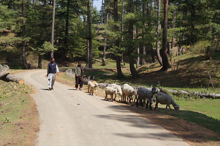
Most of the villagers live in old wooden houses though brick and mortar houses are fast replacing them. A woman offered us water as we requested to click pictures of her house. She cautioned on honey bees, which were coming out from a hole in the front wall of their house. “It is called Tamboor (traditional beehive) that gives us original honey,” she said. Behind the Tamboor was the cowshed and the family lived on the first floor.
We spent a few hours with the villagers listening to their tales of history, lifestyle, hardship and resilience. They referred to Proangam, a village that has been wiped out by the vagaries of time. “The ruminants of the village are still found. Our forefathers told us that the village might have disappeared because of famine. We usually face scarcity of water,” Abdul Khaliq, another villager said.
On our return, we stopped at a pine grove to relish well-earned lunch. Bilal was gracious enough to have packed fried chicken, kebabs and Rogan Josh. We sat on the natural green, slightly wet carpet for the lunch. Occasionally, a cab passed by and the commuters offered strange looks, sometimes a hesitant smile. While descending the mountain slope on our way back, the Wullar Lake was brimming again offered an entirely different afternoon look.
As usual, we complained that it was a short trip and required more time to absorb the essence of this bewitchingly beautiful hill station. We promised to return to the place on an elaborate trip. By the mid-summer, we were told, the local schools would make a beeline to the place.


