
Source of drinking water to nearly a quarter million population of Srinagar, the Doodganga rivulet has endured abusive illegal mining in the last six years and a criminal intervention that put most of the city’s uptown waste into the same water body. A long battle in the court of law has forced authorities to relook their questionable conduct, reports Babra Wani
For Ghulam Rasool, 55, a resident of Chanapora (Srinagar), Doodhganga has been the water source for his locality for as long as he can remember. “We as children used to go and play near Doodhganga, swim in it and then rest around,” he recalls his fond childhood memories. “Majority of my friendships were formed around this river.”
Not anymore. “Doodhganga is no longer what it used to be. Nowadays it looks more like a sewage drain.”
Not so long ago, Doodhganga provided drinking water to the majority of uptown Srinagar. It is now gradually dying as illegal mining in its initial course, dumping of solid and liquid waste within the city and discharge of sewage is squeezing life out of the rivulet that used to be a Ganga of milk, its Kashmiri name. Owing to its crisis, the rivulet has remained in the news as some people are desperately trying to force a halt on the series of biotic interventions within and outside Srinagar.
The River Rises
Doodhganga also known as chazz kul is a tributary of the River Jhelum, the main water body that drains the entire Kashmir, and flows from higher reaches of Yusmarg called Chazken Naad, near Liddermarg. It originates from Pir Panjal glaciers near Tattakoti mountain peak Shankar Bul Bul located at an altitude of 4500 metres. The initial portion of the stream is glacial fed and later springs, and several smaller lakes, also fed by snowfields, add to its discharge.
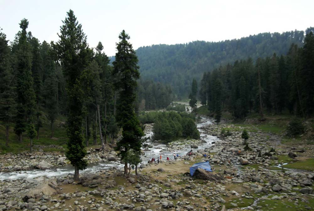
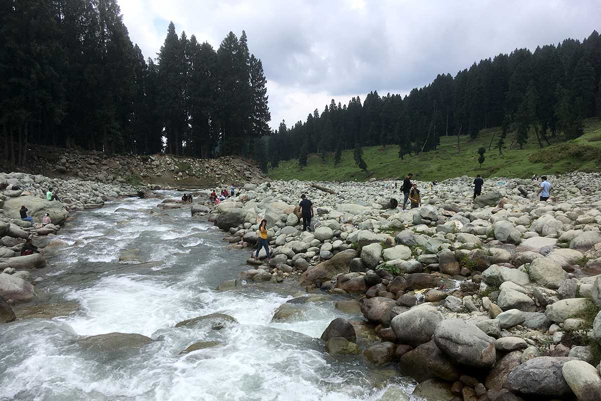
It flows through the picturesque valleys of Budgam and Pulwama for as long as 45 kilometres, before reaching Srinagar. For most of its course, it has crystal-clear waters, which look like milky white, that gives it a unique name. Doodhganga banks are popular spots for nature enthusiasts, hikers, and anglers due to their peaceful surroundings and beautiful green meadows.
In Srinagar, its natural course was bisected with one moving directly into a wetland and another draining part of Alochi Bagh and Batamaloo before landing in Jhelum. In the last 30 years, the Batamaloo canal was progressively buried beneath concrete structures, parks, and bus stops from Batamaloo to Shalteng. In the September 2014 floods, the flood waters chose the same elevation to inundate the entire belt from Batamaloo to Qamarwari.
The Doodganga watershed is spread over 600 sq km, according to joint research by Jamia Millia’s scholars Haroon Sajjad and Mohammad Iqbal. Their 2012 study, Impact of urbanization on land use/land cover of Dudhganga Watershed of Kashmir Valley, India, suggests that the belt witnessed massive urbanisation between 1991 and 2010. “Over the last 20 years, the built-up area has increased by approximately 5056 hectares at an average rate of 252 hectares/year. The area under plantation has increased by 1103 hectares at an average rate of 55 hectares/year. The area under agriculture has decreased by 3241 hectares at an average rate of 162 hectares/year, pasture has decreased by 2665 hectares at an average rate of 133 hectares/year, scrubland has decreased by 2060 hectares at an average rate of 103 hectares/year, forest has decreased by 847 hectares at an average rate of 42 hectares/year, while water bodies have decreased by 646 hectares at an average rate of 32 hectares/year,” the study revealed. “The speed of regional land use change in Dudhganga watershed has been 15.2% over 20 years. It depicts that 0.76% of land use is changing in the study area per annum.”
The study pointed out a drastic decrease in agricultural land in the watershed’s lower reaches as a result of which quantitative changes like reckless deforestation took place in the upper areas. The lower reaches witnessed 153 per cent growth in population from around one lakh to 26 lakh in 20 years, it added.
In Crisis
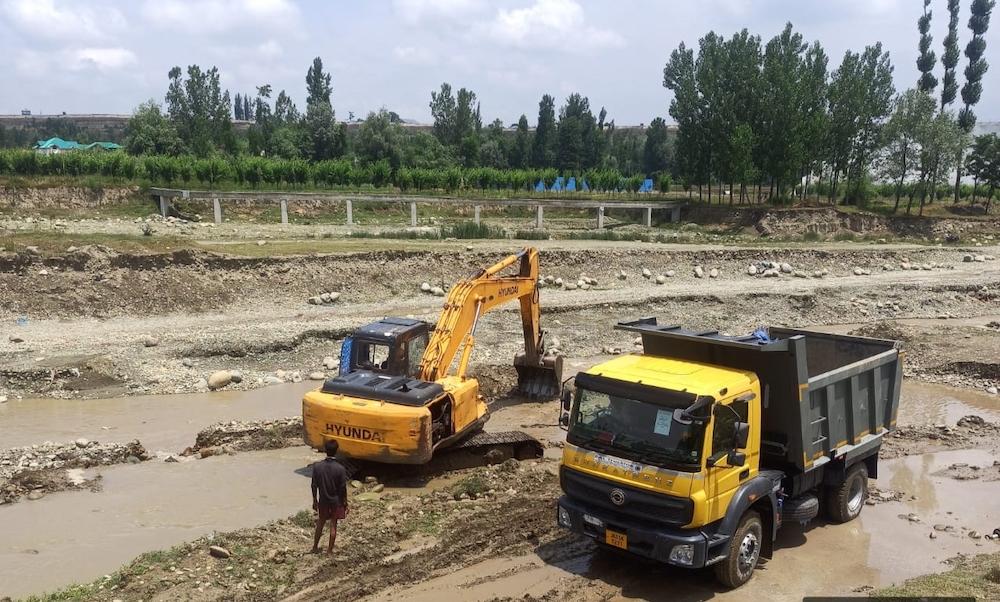
The Rivulet is facing two major issues at both ends. In the upper areas, it has been subjected to massive mining as a result of which it is facing a serious course crisis. As it moves down, the people continuously use it as a dumping sewage line.
Pic: Raja Muzaffar Bhat
Solid and liquid waste from a dozen villages and places including Chadoora town right from Branwar to Kralpora via Surasyar, Dadompora, Kralwari, Sogam, Chadoora, Hanji Gund, Wathoora and Kralpora goes into the rivulet. Its water quality changes with every village it has fed during its history.
“Right from Braiwar, the people have availed Swach Bharat grants to create toilets but neither of them has sceptic tanks,” environmental activist, Raja Muzaffar said. “They simply throw their waste into this river throughout its course and it does not stop anywhere till the river lands in the Srinagar wetland.”
It enters Srinagar as a water body with a water quality that is unfit for any human use. Though in Srinagar periphery, the youngsters used to bathe and swim in it the water quality deterioration has put a halt in the practice as it triggers allergies.
“It is no longer pleasing to the yes, it no longer smells nice,” regrets Ghulam Rasool. “I miss the old one. It was so pure and so fresh and people from two districts were dependent on it.”
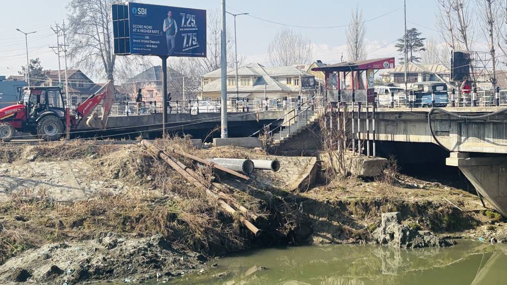
Between its entry into the city and its exit into a wetland, the water body is the main dumping ground for waste. All localities pump their waste into it and the major pump stations are in Chanpora, Natipora, near the Bone and Joints Hospital at Barzulla, Bulbul Bagh and a locality of Batamaloo. These giant water pumps drain the entire waste from the localities on either side of the rivulet and dump it into this river, many times a day. Interestingly these pumps are being called Dewatering Pumping Stations suggesting they drain out water that collects as a result of rain or storms but the fact is that they simply pump out human waste. “Within SMC limits in the city, there are 13 pumping stations at work,” Raja said. Interestingly, six to eight pumps were installed post floods using the World Bank funds.
Still Dependent
This is even though the people in all these areas and throughout its course are still dependent on it. The entire tapped water that is supplied to Hyderpora, Pir Bagh, Huhmama, Rawalpora, Chanapora, Bagh-e-Mehtab, Kralpora, Jawahar Nagar and Batamaloo is sourced from the same rivulet. The Public Health Engineering (now Jal Shakti) is draining the water from the Budgam hills and supplying it to nearly eight lakh people in the city.
The count excludes scores of villages in the city periphery that get the draining water from this rivulet, directly or indirectly.
Almost five decades ago, officials in the PHE said, a water treatment plant was established at Kralapora. Later three more units were added to it. In this plant, the water is treated and then supplied for consumption.
Poisoned Waters
According to a study Assessment of spatial variation in water quality of Doodhganga stream in Kashmir Himalaya carried out by Shakeel Ahmed Dar, SA Mir and three others in Sher e Kashmir University of Agricultural Sciences And Technology (SKUAST-K), the massive pollution has seriously compromised the water body. “Analyses of water parameters revealed a significant change in physicochemical properties of Doodhganga stream from upper reaches to lower reaches. Water quality of Doodhganga stream showed an increased load of nutrients downstream, particularly in middle and lower reaches,” the study found out. “The main factors responsible for changing water quality are discharge of agricultural and domestic wastes into the stream, erosion of river banks due to the excessive excavation of sand, increased urbanization and construction of commercial units in the riparian area of the stream.”
The study noted that the change in the Land Use and Land Cover (LULC) particularly, the “conversion of catchment area into built up and shrinking of water bodies increases pollution load in Doodhganga stream” has impacted the water body further.
What is interesting is that the most recent water analysis carried out under the orders of a quasi-judicial body showed that while the quality is unfit for human use, it is very bad at the two points where the water is lifted for tapped water schemes. There are two points where the water is lifted for treatment and supply – upper Chadoora and Kralpora. Analysis at both the points suggested the quality is hugely bad, people privy of the happening said.
Nearing Extinction
With Srinagar expanding fast and authorities not offering any alternative, the traditional sewage system eventually pumps the entire waste into this canal. It is on the verge of extinction and has started to lose its width, the same process that its course in Batamaloo saw. Now, even the government has formally got into the main river and started expanding the small road stretch opposite the new block of the Bone and Joints Hospital. Road abutments are almost nearing the middle of the river course and nobody has cried a concern.
The illegal riverbed mining and the encroachment on the embankments are the main contributing factors to the shrinkage of the river. The river unfortunately faces illegal mining at Chadoora and at Hokersar wetland, where the river passes through. “They use heavy machinery and do not adhere to the rules of riverbed mining, affecting the river badly,” Dr Raja Muzaffar, who is working for the betterment of the river, said. “There are certain rulings and regulations that one has to follow to carry out mining in a river so that the ecology of the water body is not tempered with, but those rules are not followed.”
The NGT Case
In 2021, Raja took the case to NGT primarily to tackle the pollution, It was during the trial that he came across the illegal mining part of the vandalism. With time, he could assess the illegality of how heavy machinery was being used to exploit the rivulet and what had been the long and short-term costs for the area.
As the trial commenced, interesting skeletons started tumbling out of Kashmir’s fragile cupboard. A year after the trial, the NGT imposed Jammu and Kashmir government a penalty of three crore rupees. In the second go, a Rs 35 crore penalty was imposed. As the government agencies started dithering on the promises they made to the NGT, another Rs 42.5 crore penalty was imposed.
The NGT ensured that the heavy machinery was not used in the riverbed. By the time, the rule of law was enforced, the river had changed course at many places. “Ahead of Chadoora, the riverbed has gone deep and it has created a situation that all the bore wells and the springs have dried up,” Raja said. “While the penalties have been imposed, will this critical impact be reversed?”
“It appears that there is continued violation of the Water Act to the prejudice of the environment and public health which remains unchecked,” the NGT order by Justice Sudhir Aggarwal and Dr A Senthil Vel (Expert Member) read. It directed the constitution of a five-member Joint Committee of CPCB, JK PCC, Deputy Commissioners, Srinagar and Budgam and the Director, Urban Local Bodies, J&K, with JKPCB as the nodal agency, for compliance and coordination.

The river has been abused so much that there are several police cases. Irrigation and Flood Control Department officials said several FIRs have been filed against the illegal mining throughout the river, “Since Doodhganga is a long river, it spans over more than forty kilometres there are several police stations along the way where these FIRs have been filed. Also, our department has always made sure that the river gets free from these illegal activities.” Residents said the use of heavy machines for riverbed mining has stopped since May 27, 2022.
The Plan
Authorities did respond to the frequent appearances and orders differently. In 2023, for instance, the Srinagar Municipal Corporation (SMC) said it would restore the stream under the Doodhganda Rejuvenation and Restoration Project. “Whereas as, rejuvenation and restoration of Doodh Ganga Nallah from Allochi Bagh to Chatabal has been taken up under Srinagar Smart City Limited with Drainage Circle (Civil), SMC as the executing agency,” the public notice read. “Whereas it has been found that several encroachments and illegal structures have come up on the site of nallah. Whereas removal of these encroachments and illegal structures and restoration of nallah is important for flood and stormwater management in the city.”
The SMC’s public notice gave a week to encroachers “to remove all encroachments and illegal structures” erected on and along the nallah, failing which the SMC threatened to “initiate action including removal of these encroachments at the risk and cost of the offenders and encroachers.” Within days, the localities between Haft Chinar and Batamaloo protested and the initiative evaporated.
Eventually, the government submitted to the NGT that it would create a chain of Sewage Treatment Plants (STP) to prevent the addition of waste into the water body. The overall fund requirement was put at Rs 142 crore. The NGT permitted the use of penalty amounts for the process.
“What I am told is that they have generated DPR for these STPs and the NGT has permitted them to spend around Rs 50 crore for the first phase,” Raja said. “They are already delayed by around 18 months. To start with they have now acquired some land in Chanpora for an STP but I am unaware of its capacity and the technology.” Once the initial phase takes off, the DPR for the second phase will get approval, Raja said, asserting this is what he has been informed during the trial.


