
After remaining invincible and impregnable for centuries, the mighty Pir Panchal is witnessing enormous developmental activity for a new expressway, a challenging railway line and most of the dam-fed hydropower projects involving an investment of tens of thousands of crores. At places, this is triggering the fragile range to cave in at the cost of homes and livelihoods of age-old villages, a situation that experts believe could have been avoided with better pre-feasibility studies and sophisticated project implementation, reports Masood Hussain
Anticipated for years, finally, the increased incidence of land subsidence and sinking in the Pir Panchal Mountains is Jammu and Kashmir’s new normal. The young fragile and unstable mountain range separating Kashmir from the rest of the world is in news frequently as the slopes housing small habitations for centuries are caving in.
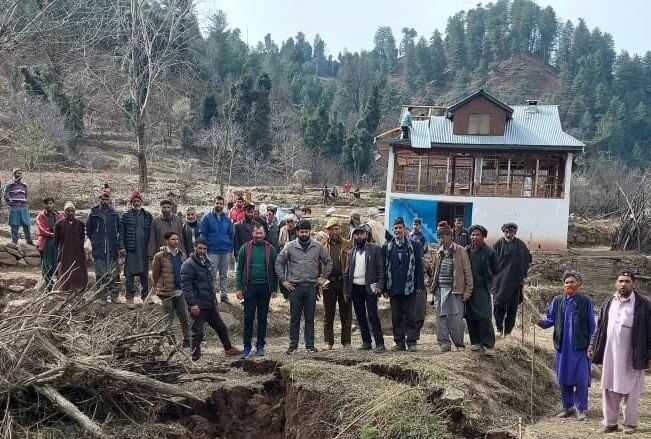
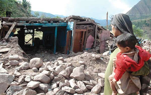
On February 19, 2023, around 16 structures of Duksar Dalwa (Duksar Dal), a hamlet almost 45 km uphill from Ramban, suffered serious damage as the land caved in. It crippled road connectivity between Gool and Ramban where almost 500 meters developed cracks, tripped the electric supply and snapped the water supply. Three homes developed cracks forcing authorities to shift the impacted population to safer areas.
Officials said while they are working overtime to resume power and water supplies, they are also improving the Dharam-Salballa road to make it an alternative supply route to the “literally disconnected” area. In the sinking village, the official encouraged the residents to move swiftly to safer spots. For residents, however, the gradual 3-day sinking was a painful watch of their life earnings slowly cracking up and becoming black holes over hills.
It started with a crater that widened to almost 500 meters during two nights, making almost everything around unsafe, unstable and life-threatening. A mosque, Darsgah, the village seminary and the village graveyard were destroyed. Residents quickly exhumed a recently buried body and laid it to rest at a “safe” place.
Officials who visited the spot said the village’s agriculture fields were rendered useless, pushing residents into poverty. They lost homes and their livelihoods too.
The Duksar erasing came less than a fortnight after Doda lost a cluster of houses to a similar instance on February 3, 2023. Located on the foothills on the road to Kishtwar near Thathri, nearly 35 km from Doda, the volunteers, residents and government officials had to quickly shift 117 members of 19 families as the patch of slope housing the Nai Basti cluster gave in within three days. A total of 21 structures cracked and became unsafe.
Horrific Tunnel Collapse
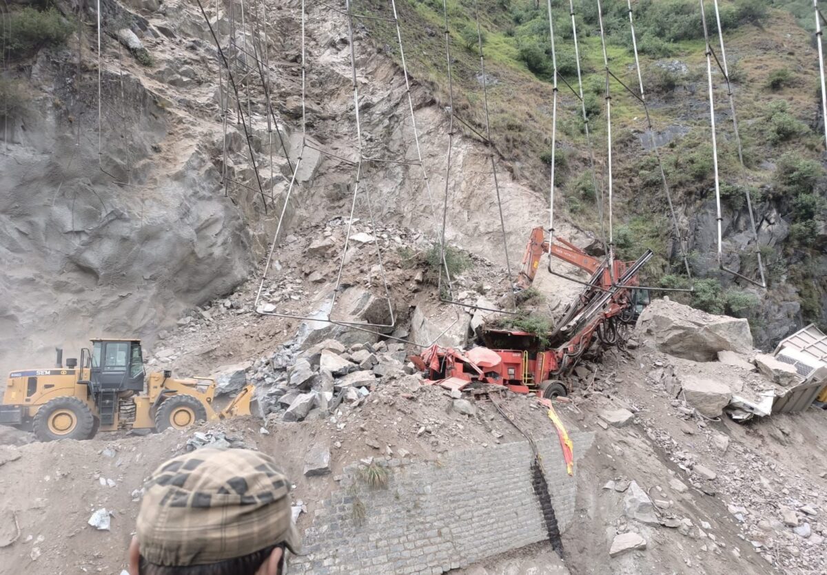
The last horrific tragedy took place on May 19, 2022, when the workers were digging into an adit (minor access to the T3 tunnel) near Khooni Nalla at Ramsu’s Makerkot area. It collapsed over them killing ten workers including two residents and eight Nepalese labourers. The tragedy struck during the day amid incessant rain but still, only two persons could be rescued alive.
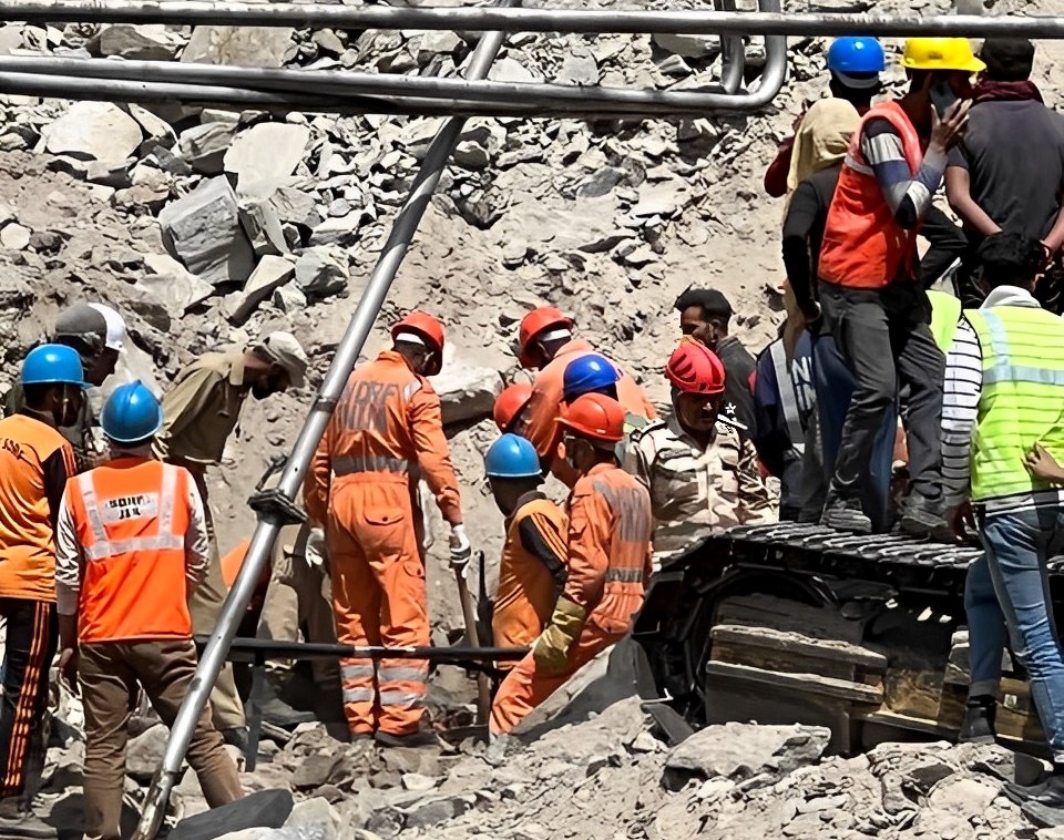
The workers were on the challenging stretch of the national highway between Digdole and Khooni Nallah, which is otherwise notorious for frequent landslides and shooting stones due to fragile geology. It was part of the twin-tube tunnel that would connect Digdole to Panthyal and was implemented by Ceigall India Limited in a JV with Patel Engineering Limited. (The contractor has been imposed a heavy fine.)
The National Highway Authority of India (NHAI) that has taken over the Jammu Srinagar national highway from Border Roads Organisation (BRO), a few years back, is constructing at least five tunnels to bypass the highway’s 3-km “killer’’ stretch from Panthyal to Makerkote. Tunnel T3 is part of this intervention.
Unlike the rest of the highway, the 36-km Banihal Ramban stretch has been the most challenging one and that is why it is still under implementation. On this stretch are six “killer spots” located on a 14-km road stretch and NHAI intends to spend Rs 2000 crore to manage this. Implementation of this would offer some safety from frequent halts owing to shooting stones at Marog, Panthial, Digdol and Battery Chashma.
Triggering Instability
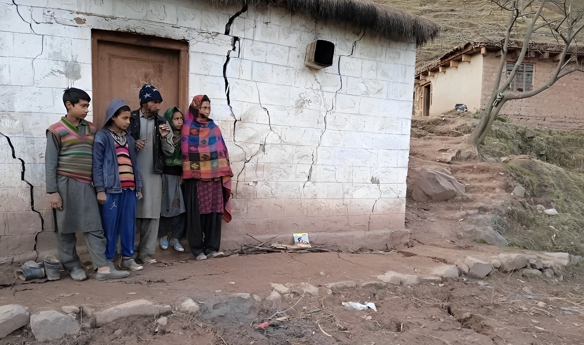
Implementation of these projects is triggering crises for the localities living around them. As many as 13 houses in Sujmatana village near Ramsu were devastated. The round-the-clock blasting for the tunnel projects and cutting work made these houses inhospitable after they developed cracks. Most of them have left their unsafe homes and migrated elsewhere. Though officials have been looking into the crisis since 2017, it is yet to be settled.
On August 4, 2022, 36 families had a providential escape when their Bassan village in Reasi became the casualty of sinking and erosion at the same time. Without any notice, landslides carried down boulders and muck that crashed the houses and put the agriculture fields out of sight. It was so abrupt, villages said, that they had no time to take their belongings along.
Officials admitted that almost 60 kanals of land sank as another 400 kanals patch was rendered useless. Almost all the fruit trees, mostly walnut and apricot, were engulfed in mud. Almost 200 meters of a PMGSY road was also downthrown by around 25 meters from its actual alignment.
The earlier worst case was reported from Dalwas when on March 28, 2020, the residents fled when their homes and fields were buried by landslides. Almost 40 households were impacted.
The village has been there for ages and never experienced any such threat. Then one day it disappeared. Residents alleged that being away from Srinagar and Jammu, deep into the mountains they hardly were reported. At one point in time when they wanted to protest, authorities invoked Covid19 concerns to prevent it.
Response Protocol
Over the years, the government response has remained unchanged. Once the reports land that spots are sinking, they as the first quick reaction, send cops, paramilitary, SDRF and revenue officials to oversee and, in most cases, extend help in quick evacuations. In stage two, the respective Deputy Commissioner writes to geologists and the Department of Geology and Mining and, off late, to the Geological Survey of India, who rush their experts to these spots. In the subsequent few days, they study the local rock formations and submit reports, part of which goes to newspapers and by and large the files get closed.
At the same time, files start rolling about relief and rehabilitation. It takes its own time. In many cases, people who lose their homes and livelihoods are yet to be properly rehabilitated.
Invariably, the policymakers and the administrators avoid two vital ingredients of the story – the assessments that the local populations make about the crisis they land in and the wider angle that remains unchanged across the Pir Panchal range.
Resident Assessments
Affected populations are unwilling to accept that these crises are natural. They see them as man-made disasters. Raqeeb Wani, a former Sarpanch of Daskar Dalwa told The Telegraph that his village’s erasing is directly linked to the construction of two railway tunnels downhill, that would link a 3km rail track between Sangaldan and Chaddi. He attributed it to the “continuous blasting” that loosens the soil and adds to the instability of the mountain.
“A few years ago, we had a similar disaster in Sangaldan a few years ago when an entire market caved in,” Wani was quoted as saying. “That also was owing to the railway project.”
In the case of Dalwas, for instance, a former lawmaker from Ramban Ashok Kumar Dogra said the “unscientific planning” of the widening of the national highway is responsible. “The highway authorities started excavation of the road from beneath the village without raising any wall on the side of the village. As no concrete measures were taken by the NHAI to protect the village and debris was also disposed of at the same place, the tragedy was bound to happen and the houses collapsed and the village sank,” Dogra told Outlook. “I will not call it a natural disaster. It was the unplanned construction that destabilised the soil of the whole area, leading to its sinking.”
Right to A Road
Pir Panchal mountain range has remained literally invincible and technically impregnable for centuries. It took decades of thought process and a lot of resources to lay a foot track between Jammu and Srinagar, to have an alternative to Mughal Road. Known to history as the Banihal Cart Road, it was difficult and always retained by Dogra despots as a private route. It remained inaccessible to people till 1922. Till the Jawahar Tunnel was inaugurated, the road would pass over the Banihal pass, the abandoned remnants of which still exist.
This made Kashmir rely on the Jhelum Valley Road (JVR) as the main highway.
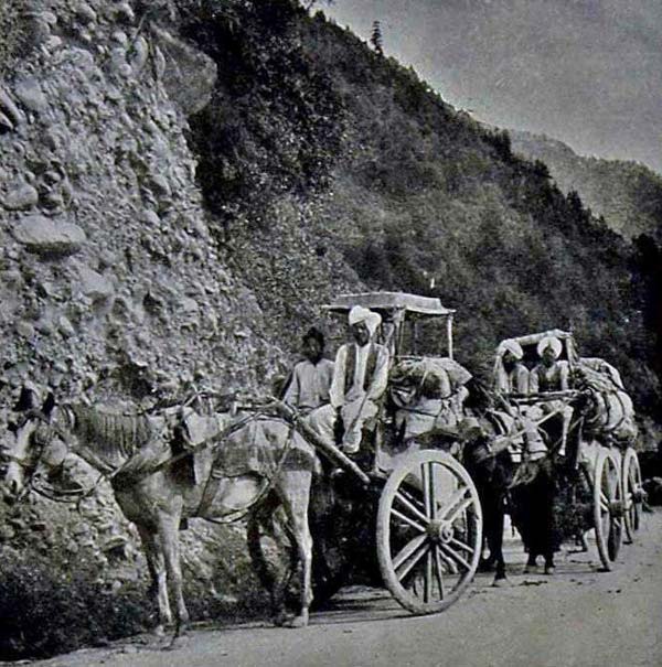
Work on JVR started in 1880 and was formally thrown open in September 1890, when Maharaja Partap Singh was driven through from Baramulla to Kohala. The construction of this gigantic road project was implemented by a major British Indian contractor M/S Spedding, Mitchell & Co and was overseen by different British engineers at different stretches. While General de Bourbel oversaw everything as the Chief Engineer Kashmir, it was Alexander Atkinson managed most of the road up to Chakoti (on the other side of LoC now) and a few parts on the Kashmir side; Farrant was in charge of construction between Chakotiand Baramulla; as EG Hebbert supervised its completion in November 1889. Resources apart, it cost too many lives. Between Chakoti and Baramulla, 54 Pathans were killed in four years. Besides, 20 lives were lost to snake bites.
Post-partition, the Banihal Road became arterial and pressure built with a surge in population and demand in Kashmir. For seven decades, this road bore the brunt of all the pressures of travel, demand and consumerism and gave in. The rise of the Kashmir apple added another pressure factor so did the security requirements.
Finally, a stage reached that the health of the national highway was directly linked to the economic well-being of Kashmir. This paved the way for the decision by the Government of India that distances need to be reduced and the highway must be improved so that commuters do not end up spending a day on a 300-km highway.
More than a decade after the first spadework, it is emerging as one of the best roads. Three major tunnels have skipped dangerous patches while reducing distance and uphill driving: a set of four small tunnels near Nandni with a combined length of 1.4 km; 9.2 km Chenani-Nashri tunnel has bypassed a gruelling uphill drive and 8.5 km Banihal-Qazigund tunnel is going to tame dangerous Banihal Pass forever.
Distance has dropped from 300 to 270 km and the travel time from 12 to around 5 hours. But the Banihal-Ramban stretch remains a challenge. Earlier, it was merely a technological crisis, now it is a serious ecological issue.
These villagers were fortunate in comparison to the Sadal hamlet of Udhampur which was buried under a massive mudslide at noon on September 6, 2014. Following incessant rains for many days, it triggered massive floods in Kashmir and the rest of the erstwhile state. As many as 41 residents from 65 households were killed by the wee hour mountain collapse that brought an almost 30-foot-thick blanket of rafted rock fragments mud, sludge and rubble.
Almost 225 residents from 48 households who somehow survived the tragedy moved to another village and are still struggling to pick the threads of their lives. Though life has returned to the village, they are still fighting for an electric supply line and the rebuilding of the school building.
An Upcoming Railway
The road is just not the only thing that is happening deep inside the Pir Panchal mountain range. While the road is being upgraded, there is a railway project in an advanced stage of implementation.
Unlike the road that is being laid over the foothills not far away from the old alignment that also followed a foot track of the eighteenth and nineteenth century, the railway track passes through a virgin area, part of which has not seen even a bus. For making rail reach Baramulla from Udhampur, the 272-km project is going to cost a whopping Rs 37012 crore of which more than ninety per cent has already been spent.
The rail is already chugging between Udhampur and Katra (25 km) since July 2014, Baramulla to Qazigund (118 km) since October 2009; and Qazigund to Baramulla (18 km) since June 2013. This leaves the most challenging stretch of 111 km between Banihal and Katra to be implemented.
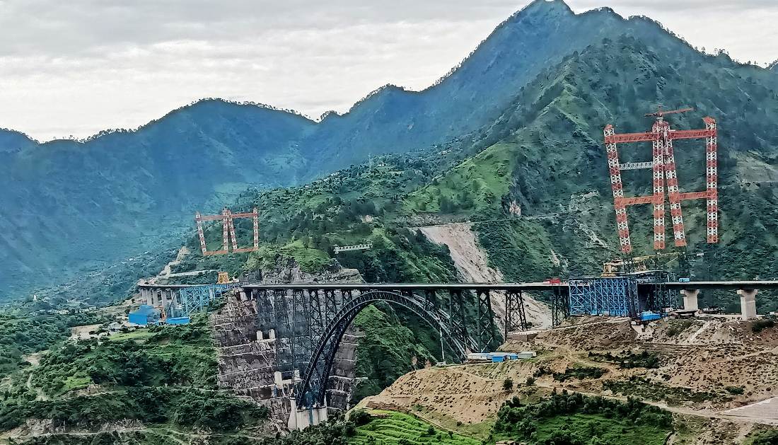
However, the cost of the track does not define the project. It is the work that details the challenge. Nearly 119 km of the entire track will pass through 38 tunnels, the longest of which is 12.77 km long.
What is interesting is that in the 111-km Banihal – Katra track, 97.42 km are tunnels and most of the rest are bridges. Railway officials have to do 163.82 km of tunnelling in total – 66.4 km are escape tunnels – to make the track possible. To make these tunnel spots accessible to men and machines, there is a network of 205 km of roads, which remain busy round the clock.
This track will have 37 bridges – totalling 7 km in length, including the iconic Chenab Bridge, which is tipped to be the highest railway bridge on earth. While this bridge is ready, the current focus is on the first cable-stayed railway bridge on Anji Khad.
With thousands of people working deep inside the mountains with basic cutting and blasting machinery a lot of activity is generated.
There were dozens of instances in which the portions of various tunnels collapsed resulting in either changing the alignment or repairing the damage and restoring the tunnel. In July 2006, an almost 3 km long tunnel on the Udhampur-Katra track gradually started sinking after massive soil swelling on the two ends making it unusable and thus delaying the project. Northern Railways later hired an Austrian consultant, Geo Consult International (GCI), to salvage the project after many years of delay. The causes of the damage were visible to even the then Chief Minister, Ghulam Nabi Azad, who said he saw “a river flowing under the tunnel”.
Several tunnels between Katra and Sangaldan witnessed “abnormal” water discharge making construction a challenging task. In Sangladan, the managers were shocked when they saw a 500-meter track between two tunnels missing one fine morning. Reported in 2006, it destroyed a vast stretch of land on a slope housing as many as 100 structures besides over 400 meters of the road connecting Mahore and Gulabgarh.
In 2016 summer of 2016, authorities shifted 124 families – almost the entire village of Dharam, after the vast patch of land that housed the hamlet caved in within three months. Though the officials attributed it to natural reasons, the residents linked the unprecedented situation to the ongoing work on the railway line passing close to the village.
Oceans In Gorges
Piercing the Pir Panchal mountains for smooth, faster and better communication is just not the only thing happening in the region. Owing to the mighty Chenab, the region is Jammu and Kashmir’s powerhouse. More than 90 per cent of the hydropower potential is restricted to the region owing to the availability of water and enough space to construct dams within the mountain gorges. This has led to a situation where the region holds a massive amount of water in its dams.
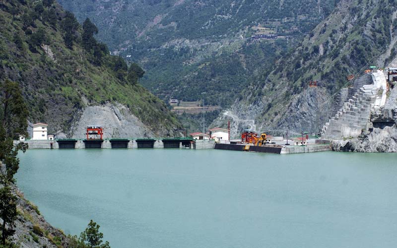
The region’s tryst with power generation started late last century with the implementation of the 900-MW Salal power project in Reasi in 1978. The project’s 1.45 million cubic meter dam has created the Salal lake which has the capacity to retain more than 28 million cubic meters of water.
Then came the 390-MW Dul-Hasti Power Project near Kishtwar. It was followed by the 900-MW Baglihar power with 1.8 cubic meters of the dam and an additional reservoir capacity of 39.5 cubic meters – a facility that has created a huge water body in the mountain gorges between Chanderkote belt and Thathri to the extent that certain localities and infrastructures had to be relocated. Quite a few people still live in the highway town of Pul Doda.
The region has many other power projects at different stages of implementation. These include 850-MW Rattle, 100-MW Pakal Dul, 624-MW Kiru, 540-MW Kwar, 800-MW Bursar, and 930-MW Kirthai-II. This is an investment of tens of thousands of crore in mountain gorges on a single river within a river length of fewer than 100 km.
Baglihar is the only project that Jammu and Kashmir’s fully-owned JKSPDC owns. Chenab Valley Power Projects Ltd, a joint venture between JKSPDC and NHPC, India’s hydropower giant, is implementing four power projects – Pakal Dul, Kiru, Kwar and Karthia-II. Salal and Dul Hasti owned fully by NHPC and Ratle is being executed under a fresh JV with JKSPDC in which the latter holds 49 per cent stakes.
Stakes apart, hydropower stations are gigantic projects. These need huge spaces for water storage – even in the case of run-of-the-river schemes, and a lot of tunnelling. All projects have main tunnels, both head race and tail race, and then there are a lot of additional adits and small tunnels for servicing. Even though most of the tunnels and the dams are concrete structures, having such critical infrastructure usually triggers soil erosion and soil swellings too often. The 110-km Batote Kishtwar road has been ailing for all these years. Never in a year could it operate for all 365 days.
Cause versus Consequence?
Science has fundamentally opposed the idea of correlating causes with consequences especially when there is no plausible explanation. In the case of the Pir Panchal region, however, there are striking correlations. For most of recent history, land sliding has been happening around the national highway only. However, in the last decade, land subsidence is a routine and it is happening at all places where developmental activities are going on.
Bhaderwah town and its surroundings are witnessing “region-exclusive” tremors almost every year. In August 2022, there were 21 tremors, reaching up to 3.9 on the Richter scale. Such summer tremors have been there in 2013, 2016, 2017, and 2018. In fact, 2013 was harrowing as the earthquakes touched 5.8 on the Richter scale.
Land patches are caving in at spots closer to some kind of major developmental activity. This is as true with railway projects as it is in road widening projects. Certain spots caved in because works were implemented without a detailed study.
In Sangaldan, for instance, when the railway track collapsed, it was pointed out by geologist Prof GM Bhat that it had been built “on a fossil slide”, which failed to withstand the weight and crumbled down. “We knew it for decades but we were never consulted,” Bhat said. “In this part of the Himalayas, rock types change after every half a kilometre.”
A respected geologist, Bhat insists that developmental activities can take place in any space that is as fragile as Pir Panchal but it needs adequate pre-implementation study and proper implementation mechanism.
“In the four-laning of the highway, the crisis would have been manageable had there been least vertical cuts,” Bhat said. “Impounding so much of water (in power projects dams) within a small patch has the potential of inducing earthquakes.” He insists that the managers of the water projects must ensure better maintenance of the tunnels or these could become a serious crisis in future.
Bhat, however, sees society also going unruly. “In Banihal near the Mahu Mangat side, a hillock is a completely populated town now,” he said. “Has anybody tried to verify where the waste goes? Are we expecting a major crisis in the coming days when the hill will cave in because of seepage?”
The region is a risky belt given its fragile geology. The upcoming railway line is built over three major active geological fault lines: the Main Boundary Thrust (between Udhampur and Katra), the Muree Thrust (between Baglihar and Sangaldan) and the Panjal Thrust (between Digdol and Mahu Mangat). “I never say railway tracks cannot cross fault lines but I believe that had local expertise been involved, extensive fieldwork would have reduced the costs and perfected the alignment”. Entire Jammu and Kashmir is classified as seismic zone-V, the highest earthquake-prone area. CAG has already done a thick report on the resources that were wasted because of the geological surprises that erupted after various rail projects were implemented. Parts of the alignment were changed and completed works were abandoned.
A fault line passes through the centre of the Baghlihar dam and most other reservoirs are very close to the fault lines underneath. “A dam burst will be worse than the earthquake itself,” Bhat, who retired recently after heading the University of Jammu’s Geology Department for a long time, said. Interestingly, the area is reporting an increased incidence of cloudbursts, seen as an indicator of climate change. “One major cloudburst near a dam can trigger unprecedented devastation.”
One such cloudburst on July 28, 2021, almost decimated Honzer, a hamlet concealed within inaccessible mountains of remote Dacchan, killing 26 residents. The bodies of almost 18 of the victims were never found.
Many geologists who studied Dalwa sinking attributed the land subsidence to water seepage and extensive cutting of steep slopes. They have suggested a robust urban land use plan, a prerequisite for any activity, especially in hilly areas.


