On a crumbling cliff above the Jhelum in peripheral Baramulla, a team of young archaeologists, mostly women, is uncovering what may be a 2,000-year-old Kushan Buddhist complex, a lost stop on the ancient road from Taxila into Kashmir. The river below is slowly eating it away, reports Mudasir Majeed Pir
We leave Srinagar at 8 am. Beyond Baramulla, the valley stops pretending to be Kashmir. The Jhelum, which has drifted lazily across the plain since the city, begins to gather itself, and the mountains close in from both sides like hands cupping water. The road west toward Uri runs along the slope, with the river falling away below it, green and heavy.
Near Sheeri, we leave the highway. A right turn takes us over a small bridge by the Lower Jhelum Hydel Power Project. For a short stretch, the car crawls down an unpaved slope, stones knocking at its underside, until we reach a canal running quiet and straight between its banks. We cross it over another small bridge and turn onto the road. The canal keeps us company for a while. I would learn later that it runs through this story too.
Then a man in a fluorescent green safety vest steps out on the slope of the hill and waves us over. He is one of the excavation team, wearing the same vest I would see again among the trenches. Without much ceremony, he points us up a narrow link road that winds through the hills. That is the way to Zehanpora.
The Kushan Site
From the main road you would never guess what lies up here: a likely Kushan site that could give Baramulla a far bigger place in the history books. If the laboratory results confirm what is still only tentative, this little-known corner of the district may never be little-known again. Kushans ruled Kashmir in the first century CE.
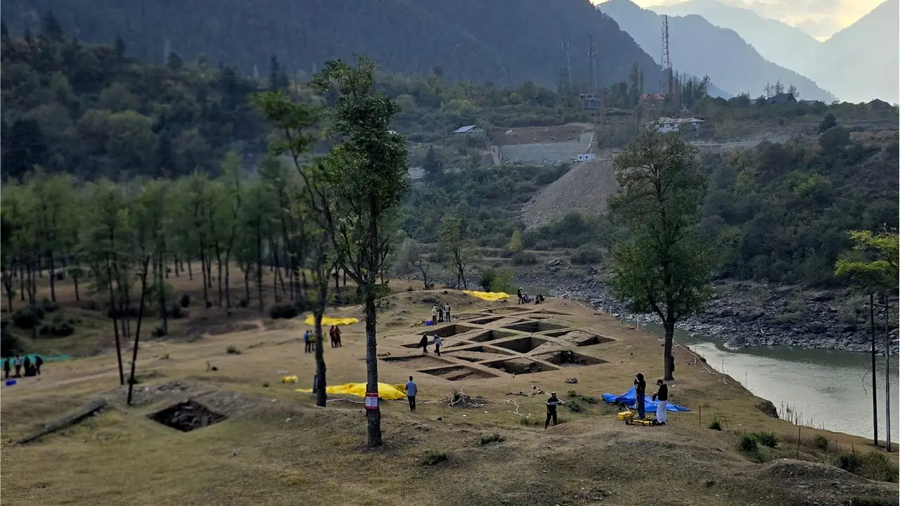
The site sits on a broad terrace that ends abruptly in a cliff, with the Jhelum flowing deep below it. Slender trees shade the ground, their leaves yellowing at the tips, and the grass has dried to the colour of straw. At first it looks like any riverside meadow in north Kashmir. Only the mounds give it away. They rise from the terrace in low, rounded swells, too regular to be accidents of geology.
A red signboard nailed to a tree announces the Zehanpora Excavation and lists its rules in two columns: what to do and what not to do. Red and white caution tape loops between bamboo stakes, printed over and over with the words MEN AT WORK. It is the first joke the site tells you, though nobody seems to have noticed it. Most of the people at work here are women scholars.
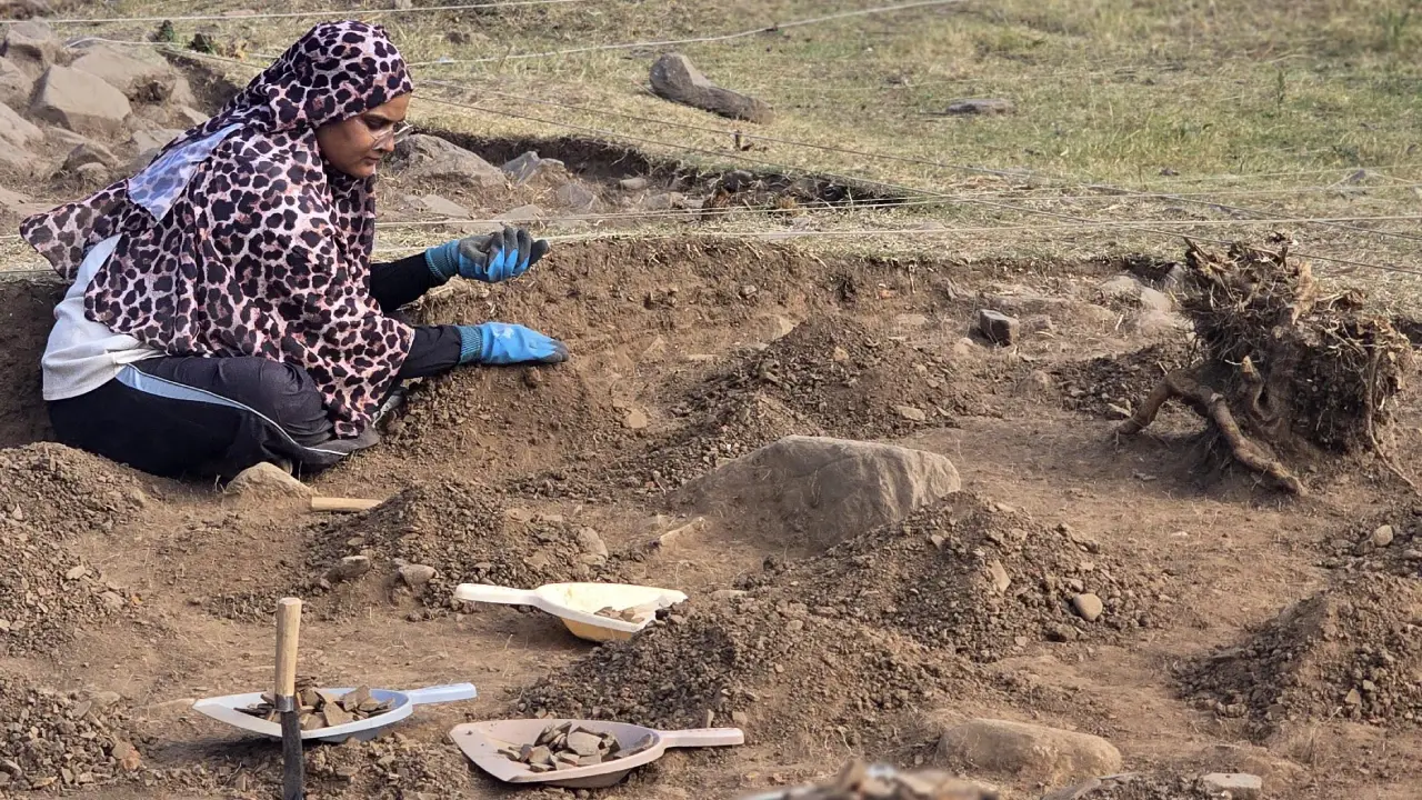
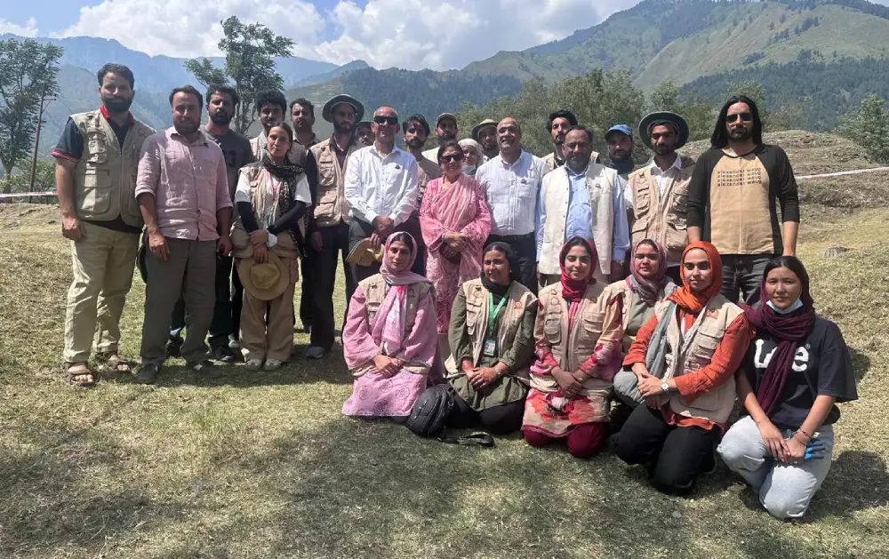
They are students of archaeology: undergraduates, master’s students and doctoral scholars. Some wear the dig’s uniform, field vests stamped on the back with the excavation’s circular emblem. Others wear cargo trousers with mud dried pale on the knees. Surgical masks against the dust, and blue nitrile gloves on almost every pair of hands.
A Grid Opening
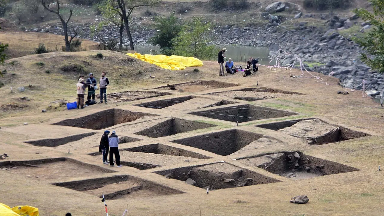
The ground itself has been opened in a grid. The trenches are cut square and deep, separated by narrow walls of untouched earth called baulks, which the excavators walk along like the ridges between paddy fields. White pegs with black-painted bases mark every corner. White string runs taut across the whole field, so the meadow looks less like land than a sheet of graph paper laid over the past. The cut faces of the trenches show the earth in bands, darker and lighter, each one a layer of time pressed flat. A yellow surveyor’s tripod stands on the edge of the grid.
Inside one trench, a young woman in a leopard-print scarf and spectacles knelt in the soil, sweeping lightly at the earth with her gloved hand a few centimetres at a time. The loosened soil had been gathered into small separate heaps around her, each kept apart from the others. Beside the trench stood a steel bucket filled with hundreds of flat terracotta pieces, reddish-brown, curved and broken. A few steps away, a student in a maroon hijab and face mask photographed something on her phone. A young man crouched on the baulk with a clipboard against his knee, writing.
Further across the terrace, small groups of students sat in circles on the ground with rows of little brown heaps laid out in front of them. They were cleaning the broken pieces of pottery with brushes and water, as delicately as if the pieces might still break.
The Chief
Dr Mohammad Ajmal Shah of the University of Kashmir’s Centre of Central Asian Studies, who directs the excavation, has been coming to this terrace for longer than most of his students have been studying the subject. He wrote his doctoral thesis on Kushan art, with a focus on Baramulla, and he talks about the site the way a farmer talks about a rice-field he has sowed every season.
He led me to the main cluster of trenches on Zehanpora-I, the only part of the site where digging is under way, and pointed down into the earth, where rough grey stones surfaced through the brown soil in two long lines.
“These are two parallel walls,” he said. “We can tentatively say that this is an apsidal hall.”
An apsidal hall is a building with one end rounded like a horseshoe. It is a plan that turns up at early Buddhist sites across the subcontinent, often as a shrine where the curved end held an object of worship and the faithful moved around it in a slow circle. Standing over the trenches, you have to work to see it. What you see are stones. It takes the string, the pegs and the patience of the people in the pits to turn those stones into a wall, and the wall into a building.
In one corner the wall had been exposed to a depth of a metre or more, the stones stacked in irregular courses and set in mud. Dr Shah stopped there.
“We could have gone a little deeper,” he said. “But this portion of the wall is leaning, tilted. If we dig further, it can come down. We can dig more, but we need the wall protected first. It is a pebble wall of Kushan times.”

The Kushans
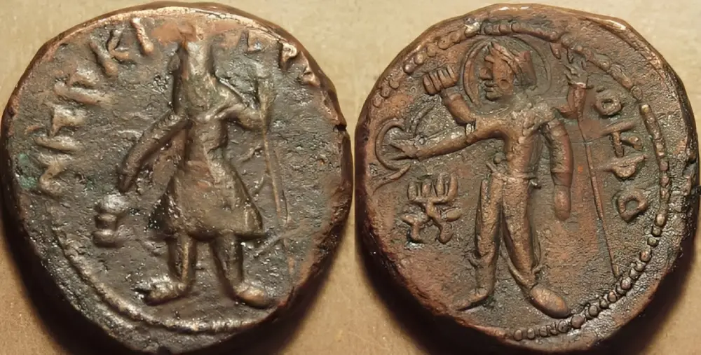
The Kushans were a Central Asian dynasty who, at their height in the first and second centuries CE, ruled an empire running from the Oxus to the Ganga, taking in Gandhara, parts of Central Asia, Mathura and Kashmir. Their most famous king, Kanishka, is remembered in Buddhist tradition as a great patron of the faith. Dr Shah and his team are tentatively dating the wall to the first century CE, roughly two thousand years ago.
I asked how they arrive at that number. Archaeology has several ways of dating a site, he explained, and the one they are relying on for now is relative dating. The same kind of pebble wall has been found at other Kushan sites in Kashmir, including excavations his team has carried out in Ganderbal, and the resemblance lets them place Zehanpora in the same period.
The pottery tells the same story. The sherds coming out of the trenches are being studied against pottery from other sites, he said, and the resemblances help them establish a link.
The firmer answer is still in a laboratory somewhere. While digging, the team struck a large log that had burnt through completely. Dr Shah pointed to a dark smear in the soil where the charcoal still lay. They have sent samples for carbon-14 dating, which gives a far firmer date than comparison alone, and he expects the results within a month or two. Until then, he said, the tentative conclusion stands: this is a Kushan site, almost two thousand years old.
The Significance
The excavation has turned up more than walls and pots. Last year, he told me, the team recovered one complete human skeleton from this same part of the site.
A few yards from where we sat, at the edge of the terrace, the largest of the mounds rises above the rest. It has been strung into its own grid, and its surface is broken by chunks of pale stone.
This, Dr Shah said, is a stupa. A stupa is the domed Buddhist monument that held relics and was walked around in devotion, and this one is an above-ground structure, which is why the team is treating it differently from the hall. Here they are not digging, only doing what he called scientific cleaning, the careful removal of debris and growth from the surface so the structure can be read without being disturbed. They have opened different contours on it, and walls have begun to show. “Alignment is showing,” he said, “which allows us to see how important the structure is.”
From the top of the mound the whole site falls into place: the grid of trenches below, the yellow tarps, the tents under the trees, the river moving past the foot of the cliff.
That, in Dr Shah’s telling, is the key to understanding Zehanpora. He first came here in 2009 and 2010, during his doctoral research, when he would travel the road to Uri. The road matters. Baramulla, he said, has huge historical significance because it lay on the transit route of the Kushans. Across what is now the Line of Control, beyond Muzaffarabad and near present-day Islamabad, lay Taxila, a city of the Indo-Greeks and later of the Kushans. The route ran from Taxila to Baramulla to Srinagar, and Baramulla was the Kushans’ entry point into Kashmir. There is evidence, he said, that this was their main road for travel, trade and commerce.
The road outlived them. When the Chinese pilgrim Xuanzang came to Kashmir in the seventh century, Dr Shah said, he came by this same route and stopped for the night at Ushkur in Baramulla. That is why settlements line the way: a couple of temples attributed to the eighth-century king Lalitaditya, and a fort on the right bank of the Jhelum that, according to textual records, the Dogras later used to collect tax. Today the national highway runs along the left bank, but he said the older road is believed to have run on the other side of the river.
The twelfth-century chronicler Kalhana, Dr Shah said, mentions Kushan cities in Kashmir. Two of them have been identified, both in Baramulla. One is at Kanispora, the Kanishkapura built by Kanishka himself. The other is Ushkur, the old Huvishkapura, named for Kanishka’s successor Huvishka. The rest have never been found.
“My focus is we should look for the others,” he said. The excavation is at a very early stage, and more evidence will come with time, but he believes they may be close to finding another Kushan city in Baramulla.
For all that, Zehanpora has almost no paper trail. There is no historical text that names it, he said, only passing mentions by a few writers over the last sixty years or so, and no in-depth account of any kind.
The French Evidence
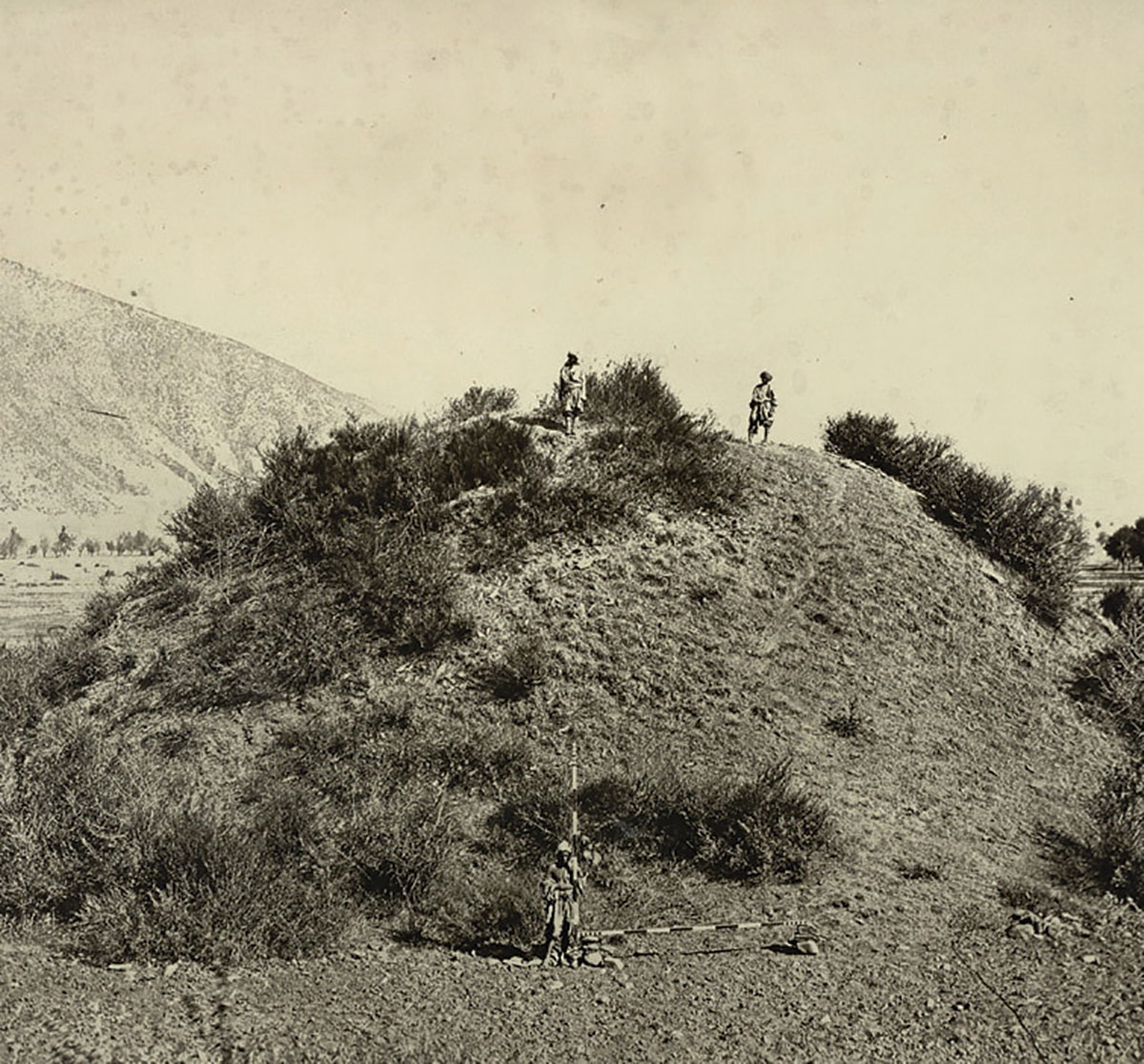
The thread that ties the site together runs through Paris. In October 2023 Dr Shah went to France on a fellowship. While there, he visited the Guimet Museum and spent time in its archival collection searching for old photographs from the British period. Many outsiders had passed through Baramulla in the colonial era. Some had dug at Ushkur and left with what they found, he said, and that material went first to museums in Lahore and was later dispersed to museums in Britain.
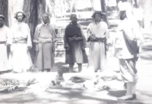
In the Guimet archive he found a photograph of this place. On the back, someone had written that these were the stupa dunes of Baramulla. The photographer had travelled to the area twice, so the image dates either to the 1860s or the 1920s. He leans toward the 1920s.
The photograph changed how he saw the site. It had been taken from the far side of the canal that runs along the road leading here, and in its background stood the stupa, the same mound we had just climbed. It showed him that the terrace he knew was not the whole of it. Across the canal, on its western side, lies another locality with two more mounds like these. For clarity, the team now calls the part on the left side of the canal Zehanpora-I, currently being excavated, and the part across the canal Zehanpora-II.
The photograph also explained something odd. In the old picture, the stupa mound looks huge. Today it seems much smaller, because when the canal was dug, its spoil was dumped on this side, raising the ground around the mound and swallowing part of its height. Local memory holds that the canal cut what was once a single site in two. Nobody can say how much of the story went into the embankments.
Dr Shah is careful to say the photograph was not where his interest began. It added to it. Going through archives is simply part of an archaeologist’s method, one of the first steps in collecting material. After his early visits, there was a long gap, and from 2017 his team began coming here regularly, looking for evidence. They found iron nails and pieces of terracotta tile, enough to know the site mattered long before he ever walked into the Guimet.
There is one more trace in the record. In 1923, he said there is a reference to a very small excavation here, which he now believes was on the far side of the canal, at Zehanpora-II. It may have been carried out by the archaeologist RC Kak, but that is not certain. Nothing from it was ever published. For more than a hundred years after that, no one paid the site serious attention, and certainly not on this scale.
Imagining The Future
The scale is the point. Reading the contours of the landscape, the team has demarcated more than ten acres, and Dr Shah thinks the site could extend beyond that. On this side of the canal it is all government land, with no encroachments. Across the canal, at Zehanpora-II, he would not call them encroachments, but there are some issues, which the department is looking into, and he expects the site to be notified for protection. “Such a huge site is nowhere in Kashmir,” he said.
Then he walked me to the edge of the terrace, and the story turned from the past to the future.
The ground does not slope down to the river. It simply stops. The dry grass runs right up to a ragged lip of earth, roots and loose stone, and then there is air, and far below, the Jhelum. I sat down there, my legs over the drop, and looked at the river for a long time.
From up here you can see exactly what it is doing. Upstream, the Jhelum comes in narrow and quick, tumbling white over a bed of dark rocks. Then, right beneath the cliff, it slows and spreads into a wide green pool.
It is a meander, Dr Shah said, and it explains everything. A river bending like this pushes hardest against the outside of its curve, cutting into whatever bank stands there, and lays down sand and stone on the inside, where the water slows. His team published a paper in July 2026 measuring how much soil has already been lost from this edge and how much more is expected to go.
“You can see how much that wall is getting derailed,” he said, gesturing back toward the leaning stones in the trench. “If we cannot conserve this site, this whole portion will go off. This site is literally on the edge.”
The boundary is slowly tapering away. There is no retaining wall, and a heavy rain could do serious damage. A retaining wall, he said, is essential. Once it is built, the excavation can be extended north as far as needed.
He has thought past that too. “In the afternoons it is very windy here. No ordinary shelter would survive it. Any cover over the excavated structures would have to be a robust tensile structure. If visitors are to come one day, there should be pavements for them, and that needs planning now rather than later,” he said.
Money, in his view, is not the obstacle. “There is no dearth of money,” he said. “All we need is the will to spend on projects like these.”
The archaeology department, he pointed out, has been spending heavily on conserving historical sites, a new director has recently taken charge, and he is hopeful the site will keep receiving the kind of support it has had so far.
It is easy to see why anyone would have built here. The terrace is flat and raised above the river, sheltered by mountains on every side, and it sits at the threshold of the valley, where travellers coming from the west would have caught their first sight of Kashmir.
By the time the light began to go, the students were dragging the yellow tarps back over the open trenches and weighting the corners with stones. The tools were gathered off the grass. The wheelbarrows were parked. The bucket of sherds was carried off toward the tents.
Below the cliff, the Jhelum kept working at the bend, patient as ever. The young students packed their things, cleaned the dust from their clothes and prepared to leave as evening approached.
For me, it was the first such experience in life: travelling to an archaeological site and engaging in conversations with experts whose work on this site has the potential to transform the historical roots of the Baramulla district and attract global attention to it.
What struck me most deeply was how young graduates, postgraduates, and PhD scholars from different places in Kashmir and outside were learning history not from books, but seeing it unfold before it goes into books.
In the team, there was a female PhD scholar from Himachal Pradesh presently enrolled at the University of Kashmir. There was also a deaf girl doing her master’s, who looked very cheerful and excited, as if this exercise were a Mars trip. At lunch, after I was done eating, I sat with a group of four: a Sikh boy, a Sikh girl, a Kashmiri Pandit boy and a Muslim girl, and spoke to them about faith and culture. It sounded interesting that youngsters from existing faiths in Kashmir were working together to locate and understand the one that preceded theirs.
When we left Zehanpora, I was quietly smiling, with a deep sense of elation at how education can bring people from different faiths together and bind them into deep friendships.